.
![File:RESIDENTS OF MULKY SQUARE, A LOW-INCOME NEIGHBORHOOD ON THE CITY'S WEST SIDE, FACE LARGE SCALE DISPLACEMENT BY A NEW... - NARA - 553518.jpg]()
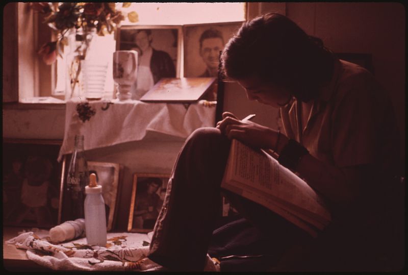
Residents of Mulky Square, a low-income neighborhood on the city's west side, face large scale displacement by a new interstate highway (I-635). Many houses have been demolished, others stand empty. For the people who remain, life goes on with very little change. On Saturday in a neighborhood tavern, Ernest Watkins of Mulky Square finds his favorite relaxation. Mr. Watkins, father of nine, is a biscuit company worker: photo by Kenneth Paik (1940-2006) for the Environmental Protection Agency, September 1973 (US National Archives)
![File:MULKY SQUARE NEIGHBORS MEET OVER A BEER. THIS LOW-INCOME NEIGHBORHOOD FACES MAJOR DISRUPTION WITH THE PROJECTED... - NARA - 553519.jpg]()
Mulky Square neighbors meet over a beer. This low-income neighborhood faces major disruption with the projected building of a new highway (I-635) through the area: photo by Kenneth Paik (1940-2006) for the Environmental Protection Agency, October 1973 (US National Archives)
![File:ERNEST WATKINS IN HIS MULKY SQUARE HOME. MR. WATKINS, FATHER OF NINE, IS A BISCUIT COMPANY WORKER - NARA - 553516.jpg]()
Ernest Watkins in his Mulky Square home. Mr. Watkins, father of nine, is a biscuit company worker: photo by Kenneth Paik (1940-2006) for the Environmental Protection Agency, October 1973 (US National Archives)
![File:ERNEST WATKINS OF MULKY SQUARE, BISCUIT COMPANY WORKER AND FATHER OF NINE, SITS ON HIS FRONT DOORSTEP WITH HIS... - NARA - 553520.jpg]()
Ernest Watkins of Mulky Square, biscuit company worker and father of nine, sits on his front doorstep with his three-year-old son: photo by Kenneth Paik (1940-2006) for the Environmental Protection Agency, October 1973 (US National Archives)
![File:ERNEST WATKINS OF MULKY SQUARE, BISCUIT COMPANY WORKER AND FATHER OF NINE, LIKES HIS BEER AND LIKES TEACHING HIS... - NARA - 553521.jpg]()
Ernest Watkins of Mulky Square, biscuit company worker and father of nine, likes his beer and likes teaching his three-year-old son to like it: photo by Kenneth Paik (1940-2006) for the Environmental Protection Agency, October 1973 (US National Archives)
![File:ERNEST WATKINS IN HIS MULKY SQUARE HOME. MR. WATKINS, FATHER OF NINE, IS A BISCUIT COMPANY WORKER - NARA - 553517.jpg]()
Ernest Watkins in his Mulky Square home. Mr. Watkins, father of nine, is a biscuit company worker: photo by Kenneth Paik (1940-2006) for the Environmental Protection Agency, October 1973 (US National Archives)
![File:WEEKENDS FOR THIS MULKY SQUARE BISCUIT COMPANY WORKER AND FATHER OF NINE MEAN BEER AND SLEEP. MULKY SQUARE, AN AREA... - NARA - 553522.jpg]()
Weekends for this Mulky Square biscuit company worker and father of nine mean beer and sleep. Mulky Square, an area of low income families on the city's west side, is soon to be torn up for a new interstate highway: photo by Kenneth Paik (1940-2006) for the Environmental Protection Agency, October 1973 (US National Archives)
![File:MRS. MAY WATKINS OF MULKY SQUARE WITH HER THREE-YEAR-OLD SON KEVIN, ONE OF NINE WATKINS CHILDREN - NARA - 553523.jpg]()
Mrs. May Watkins of Mulky Square with her three-year-old son Kevin, one of nine Watkins children: photo by Kenneth Paik (1940-1966) for the Environmental Protection Agency, October 1973 (US National Archives)
![File:MRS. MAY WATKINS CUDDLES THE YOUNGEST OF HER FAMILY OF NINE ON THE FRONT PORCH OF THEIR MULKY SQUARE HOME. THIS WEST... - NARA - 553543.jpg]()
Mrs. May Watkins cuddles the youngest of her nine children on the front porch of their of Mulky Square home. This west side neighborhood of low-income families will soon be torn up to make way for a new interstate highway: photo by Kenneth Paik (1940-1966) for the Environmental Protection Agency, October 1973 (US National Archives)
![File:THE WATKINS OF MULKY SQUARE, A FAMILY OF ELEVEN, LIVE IN THE 1600 BLOCK OF MADISON STREET, A FEW BLOCKS FROM THE AREA... - NARA - 553496.jpg]()
The Watkins of Mulky Square, a family of eleven, live in the 1600 block of Madison Street, a few blocks from the area being cleared for I-95. On the Watkins front porch: Mrs Watkins, her son, daughter-in-law and grandchild: photo by Kenneth Paik (1940-1966) for the Environmental Protection Agency, October 1973 (US National Archives)
![File:MRS. MAY WATKINS (RIGHT) SITS IN HER MULKY SQUARE HOUSE WITH THE YOUNGEST OF HER NINE CHILDREN AND A DAUGHTER-IN-LAW.... - NARA - 553544.jpg]()
A barefoot Mrs. May Watkins (right) sits in her Mulkey Square house with the youngest of her nine children and a daughter-in-law. Much of her time is spent like this. The kitchen in the background badly needs cleaning, but the incentives are lacking: photo by Kenneth Paik (1940-2006) for the Environmental Protection Agency, October 1973 (US National Archives)
![File:YOUNG KEVIN WATKINS GOES TO SLEEP WHILE HIS NEPHEW (HIS SECOND BROTHER'S SON) EATS A BOWL OF CEREAL ON THE LIVING... - NARA - 553528.jpg]()
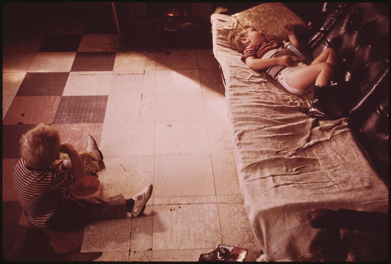
Young Kevin Watkins goes to sleep while his nephew (his second brother's son) eats a bowl of cereal on the living room floor. Kevin is one of nine children in a Mulky Square biscuit worker's family: photo by Kenneth Paik (1940-2006) for the Environmental Protection Agency, October 1973 (US National Archives)
Residents of Mulky Square, a low-income neighborhood on the city's west side, face large scale displacement by a new interstate highway (I-635). Many houses have been demolished, others stand empty. For the people who remain, life goes on with very little change, Mrs May Watkins, mother of nine, roughhouses with son Dale and daughter-in-law on the Watkins' front porch: photo by Kenneth Paik (1940-2006) for the Environmental Protection Agency, October 1973 (US National Archives)
![File:RESIDENTS OF MULKY SQUARE, A LOW-INCOME NEIGHBORHOOD ON THE CITY'S WEST SIDE, FACE LARGE SCALE DISPLACEMENT BY A NEW... - NARA - 553501.jpg]()
Residents of Mulky Square, a low-income neighborhood on the city's west side, face large scale displacement by a new interstate highway (I-635). Many houses have been demolished, others stand empty. For the people who remain, life goes on with very little change. Mrs May Watkins, mother of nine, on the porch of her Mulky Square house: photo by Kenneth Paik (1940-2006) for the Environmental Protection Agency, October 1973 (US National Archives)
![File:DIRTY HANDS OF ONE OF THE NINE CHILDREN OF MULKY SQUARE BISCUIT WORKER HOLD SMALL NEPHEW. IN THIS FAMILY LOVE OF... - NARA - 553533.jpg]()
Dirty hands of one of the nine children of Mulky Square biscuit worker hold small nephew. In this family love of children is strong but sanitation belongs to a different world. Mulky Square is a low-income area soon to be torn up by a new interstate highway: photo by Kenneth Paik (1940-2006) for the Environmental Protection Agency, October 1973 (US National Archives)
![File:A BAREFOOT MRS. MAY WATKINS, MOTHER OF NINE, SHARES COUCH IN HER MULKY SQUARE LIVING ROOM WITH TWO OF HER DAUGHTERS.... - NARA - 553542.tif]()
A barefoot Mrs. May Watkins, mother of nine, shares couch in her Mulkey Square living room, Kansas City, with two of her daughters. They find shoes more to their liking: photo by Kenneth Paik (1940-2006) for the Environmental Protection Agency, October 1973 (US National Archives)
![]()
Mrs. May Watkins and one of her nine children in the living room of their Mulky Square home, Kansas City. Mrs. Watkins' husband works for a local biscuit company: photo by Kenneth Paik (1940-2006) for the Environmental Protection Agency, October 1973 (US National Archives)
![File:DIANE WATKINS, ONE OF NINE CHILDREN OF A MULKY SQUARE FAMILY EATS ON THE LIVING ROOM COUCH. THE ONLY TABLE IN THE... - NARA - 553524.jpg]()
Diane Watkins, one of nine children of a Mulky Square family, eats on the living room couch. The only table in the house is occupied by her 14-year-old sister: photo by Kenneth Paik (1940-2006) for the Environmental Protection Agency, October 1973 (US National Archives)
![File:DIANE WATKINS, 9, IN BEDROOM OF HER FAMILY'S HOUSE IN MULKY SQUARE. DIANE IS ONE OF THE NINE CHILDREN OF A BISCUIT... - NARA - 553532.jpg]()
Diane Watkins, 9, in bedroom of her family's house in Mulky Square. Diane is one of the nine children of a biscuit company worker and his wife. Area soon to be torn up to make way for a new interstate highway (I-635): photo by Kenneth Paik (1940-2006) for the Environmental Protection Agency, October 1973 (US National Archives)
![File:GOING TO EXCHANGE EMPTIES FOR MORE SODA POP IN MULKY SQUARE, A LOW-INCOME NEIGHBORHOOD ON THE CITY'S WEST SIDE.... - NARA - 553547.jpg]()
Going to exchange empties for more soda pop in Mulky Square, a low-income neighborhood on the city's west side. Residents face uprooting by a new interstate highway (I-95): photo by Kenneth Paik (1940-2006) for the Environmental Protection Agency, October 1973 (US National Archives)
![File:THE WATKINS OF MULKY SQUARE, A FAMILY OF ELEVEN, LIVE IN THE 1600 BLOCK OF MADISON STREET, A FEW BLOCKS FROM THE AREA... - NARA - 553488.jpg]()
The Watkins of Mulky Square, a family of eleven, live in the 1600 block of Madison Street, a few blocks from the area being cleared for I-635. The older Watkins boys tinker with cars, a favorite occupation: photo by Kenneth Paik (1940-2006) for the Environmental Protection Agency, October 1973 (US National Archives)
![File:RESIDENTS OF MULKY SQUARE, A LOW-INCOME NEIGHBORHOOD ON THE CITY'S WEST SIDE, FACE LARGE SCALE DISPLACEMENT BY A NEW... - NARA - 553502.jpg]()
Residents of Mulky Square, a low-income neighborhood on the city's west side, face large scale displacement by a new interstate highway (I-635). Many houses have been demolished, others stand empty. For the people who remain, life goes on with very little change. Mrs May Watkins with the wife of one of her sons on the Watkins' front porch: photo by Kenneth Paik (1940-2006) for the Environmental Protection Agency, October 1973 (US National Archives)
Wife of Dale Watkins, one of nine children of a Mulky Square family, performs a little cosmetic surgery on her husband's face. Mulky Square is a deteriorating neighborhood of low-income famlies, soon to be torn up to make way for a new interstate highway: photo by Kenneth Paik (1940-1966) for the Environmental Protection Agency, October 1973 (US National Archives)
![File:WIFE OF DALE WATKINS, ONE OF THE NINE CHILDREN OF A MULKY SQUARE FAMILY, PERFORMS A LITTLE COSMETIC SURGERY ON... - NARA - 553546.jpg]()
Wife of Dale Watkins, one of nine children of a Mulky Square family, performs a little cosmetic surgery on her husbands's face. Mulky Square is a deteriorating neighborhood of low-income famlies, soon to be torn up to make way for a new interstate highway: photo by Kenneth Paik (1940-1966) for the Environmental Protection Agency, October 1973 (US National Archives)
![File:DOODLES OF DALE WATKINS, ONE OF NINE CHILDREN IN A MULKY SQUARE BISCUIT WORKER'S FAMILY AN ISOLATED, POOR, AND... - NARA - 553540.tif]()
Doodles of Dale Watkins, one of nine children in a Mulky Square biscuit worker's family. An isolated, poor and deteriorating neighborhood, Mulky Square faces major disruption from a new interstate highway: photo by Kenneth Paik (1940-2006): photo by Kenneth Paik (1940-2006) for the Environmental Protection Agency, October 1973 (US National Archives)
![File:BILLY AND SANDY WATKINS CALL TO A FRIEND ON THE STREET FROM THE DOORWAY OF THEIR MULKY SQUARE HOUSE - NARA - 553536.jpg]()
Billy and Sandy Watkins call to a friend on the street from the doorway of their Mulkey Square home, Kansas City: photo by Kenneth Paik (1940-2006) for the Environmental Protection Agency, October 1973 (US National Archives)
![File:BILLY WATKINS, ONE OF NINE CHILDREN IN A BISCUIT WORKER'S FAMILY, BROODS ON THE STAIRS OF THEIR MULKY SQUARE HOUSE - NARA - 553534.jpg]()
Billy Watkins, one of nine children in a biscuit worker's family, broods on the stairs of their Mulky Square house: photo by Kenneth Paik (1940-2006) for the Environmental Protection Agency, October 1973 (US National Archives)
![File:BILLY WATKINS EATS A BOWL OF CEREAL IN THE LIVING ROOM OF HIS HOUSE IN MULKY SQUARE. BILLY IS ONE OF 9 CHILDREN OF A... - NARA - 553529.jpg]()
Billy Watkins eats a bowl of cereal in the living room of his house in Mulky Square, Kansas City, Billy is one of nine children of a biscuit company worker and his wife: photo by Kenneth Paik (1940-2006) for the Environmental Protection Agency, October 1973 (US National Archives)
![File:LOOK, MA, ONE WHEEL. BILLY WATKINS OF MULKY SQUARE CAN RIDE LIKE THIS FOR A WHOLE BLOCK, HAS EVEN OFFERED TO TEACH... - NARA - 553515.jpg]()
Look, Ma, one wheel. Billy Watkins of Mulkey Square, Kansas City, can ride like this for a whole block, and has even offered to teach others the trick for a small fee -- but so far has found no takers: photo by Kenneth Paik (1940-2006) for the Environmental Protection Agency, September 1973 (US National Archives)
![File:RESIDENTS OF MULKY SQUARE, A LOW-INCOME NEIGHBORHOOD ON THE CITY'S WEST SIDE, FACE LARGE SCALE DISPLACEMENT BY A NEW... - NARA - 553538.jpg]()
Residents of Mulky Square, a low-income neighborhood on the city's west side, face large scale displacement by a new interstate highway (I-635). Many houses have been demolished, others stand empty. For the people who remain, life goes on with very little change. Billy Watkins plays with an old tire in a cleared-out section now used as a dump. Billy, one of nine children in a biscuit worker's family, doesn't go to school and has a lot of time to kill: photo by Kenneth Paik (1940-2006) for the Environmental Protection Agency, October 1973 (US National Archives)
Residents of Mulky Square, a low-income neighborhood on the city's west side, face large scale displacement by a new interstate highway (I-635). Many houses have been demolished, others stand empty. For the people who remain, life goes on with very little change. Billy Watkins, one of nine children in a biscuit worker's family, passes a run-down apartment building on his way home. The tenants have gone, the building is closed: photo by Kenneth Paik (1940-2006) for the Environmental Protection Agency, October 1973 (US National Archives)
Residents of Mulky Square, a low-income neighborhood on the city's west side, face large scale displacement by a new interstate highway (I-635). Many houses have been demolished, others stand empty. For the people who remain, life goes on with very little change. Billy Watkins, one of nine children in a biscuit worker's family, passes through a now-deserted section of the neighborhood. Billy does not go to school and much of each day is spent "killing time": photo by Kenneth Paik (1940-2006) for the Environmental Protection Agency, October 1973 (US National Archives)
![File:MULKY SQUARE, AN ISOLATED, LOW-INCOME AREA ON THE CITY'S WEST SIDE, IS SOON TO BE TORN UP TO MAKE WAY FOR A NEW... - NARA - 553553.jpg]()
Mulky Square, an isolated, low-income area on the city's west side, is soon to be torn up to make way for a new interstate highway. Many houses stand vacant. A part of this building is still occupied by a family. Their children play around the building: photo by Kenneth Paik (1940-1966) for the Environmental Protection Agency, September 1973 (US National Archives)
![File:LOOKING OVER "WEST BOTTOMS" OF KANSAS CITY FROM MULKY SQUARE PARK, A CITY FACILITY. PARK MONUMENT MAKES GOOD CLIMBING - NARA - 553513.jpg]()
Looking over the "West Bottoms" of Kansas City from Mulky Square Park, a city facility. Park monument makes good climbing: photo by Kenneth Paik (1940-2006) for the Environmental Protection Agency, September 1973 (US National Archives)
Playing football at Mulky Square Park, a city facility: photo by Kenneth Paik (1940-1966) for the Environmental Protection Agency, September 1973 (US National Archives)
![File:MULKY SQUARE AREA CHILDREN PLAYING IN ROADSIDE TRASH WITHIN FIVE BLOCKS OF THE AREA ARE A PARK AND RECREATION AREA... - NARA - 553507.jpg]()
Mulky Square area children playing in roadside trash. Within five blocks of the area are a park and recreation area provided by the city: photo by Kenneth Paik (1940-2006) for the Environmental Protection Agency, September 1973 (US National Archives)
![File:MULKY SQUARE YOUTH WITH COWBOY GEAR AND TRANSISTOR - NARA - 553508.jpg]()
Mulky Square youth with cowboy gear and transistor: photo by Kenneth Paik (1940-2006) for the Environmental Protection Agency, September 1973 (US National Archives)
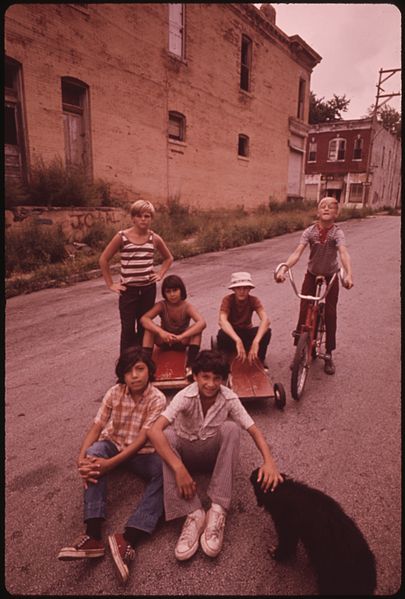
Residents of Mulky Square, a low-income neighborhood on the city's west side, face large scale displacement by a new interstate highway (I-635). Many houses have been demolished, others stand empty. For the people who remain, life goes on with very little change. For neighborhood children, go-cart races are still big weekend fun: photo by Kenneth Paik (1940-2006) for the Environmental Protection Agency's Documerica project, October 1973 (US National Archives)
![File:CHILDREN PLAY IN MULKY SQUARE, A LOW-INCOME AREA SOON TO BE TORN UP TO MAKE WAY FOR A NEW INTERSTATE HIGHWAY - NARA - 553526.jpg]()
Children play in Mulky Square, a low income area soon to be torn up to make way for a new interstate highway: photo by Kenneth Paik (1940-2006) for the Environmental Protection Agency, October 1973 (US National Archives)
![File:MULKY SQUARE YOUNGSTERS SHOW OFF THEIR TATTOOS - EVERYBODY HAS THEM. "IT DON'T HURT," THEY ASSURE THE PHOTOGRAPHER - NARA - 553511.jpg]()
Mulky Square youngsters show off their tattoos -- everybody has them. "It don't hurt," they assure the photographer: photo by Kenneth Paik (1940-2006) for the Environmental Protection Agency, September 1973 (US National Archives)
![File:MULKY SQUARE GIRL OFFERS HER RACCOON, BUT IT STILL ISN'T GOOD ENOUGH TO WIN HER A PLACE IN THE GANG - NARA - 553514.jpg]()
Mulky Square girl offers her raccoon, but it still isn't good enough to win her a place in the gang: photo by Kenneth Paik (1940-2006) for the Environmental Protection Agency, September 1973 (US National Archives)
![]()
Harold, a Mulkey Square boy who says that he spent a year at the Missouri Boys' Reformatory in Boonville, shows off his smoking style and his tattoos. Younger boys accept Harold as a natural leader: photo by Kenneth Paik (1940-2006) for the Environmental Protection Agency, October 1973 (US National Archives)
![]()
Mulky Square is a neighborhood on the west side of Kansas City, an area of low-income dwellings. I-635 will cut right through Mulky Square, which is already isolated by railroad yards on the west, I-70 on the north and I-35 plus a 4-lane freeway on the east. Buildings are being closed down. These brothers talk about moving to California as they sit on the steps of an already abandoned house on the 1600 block of Madison Street outside the area being cleared for I-635: photo by Kenneth Paik (1940-2006): photo by Kenneth Paik (1940-2006) for the Environmental Protection Agency, October 1973 (US National Archives)
![File:MULKY SQUARE BOY WALKS PAST BUILDING MARKED FOR DEMOLITION TO MAKE WAY FOR A NEW INTERSTATE HIGHWAY (I-635). THE... - NARA - 553506.jpg]()
Mulky Square boy walks past a building marked for demolition to make way for a new interstate highway (I-635). The building of the road through the area means large-scale displacement for the residents: photo by Kenneth Paik (1940-2006) for the Environmental Protection Agency, October 1973 (US National Archives)
![File:ELDERLY RESIDENT OF MULKY SQUARE MUST SOON FIND NEW LODGING. HER PRESENT HOME IS IN THE PATH OF I-635 - NARA - 553482.jpg]()
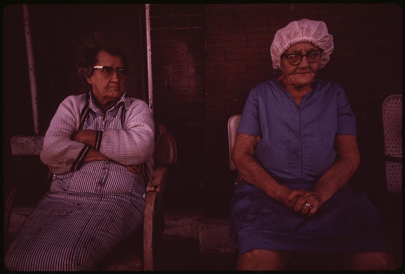
Elderly resident of Mulky Square must soon find new lodging. Her present home is in the path of I-635: photo by Kenneth Paik (1940-2006): photo by Kenneth Paik (1940-2006) for the Environmental Protection Agency, October 1973 (US National Archives)
![File:MULKY SQUARE IS A NEIGHBORHOOD IN THE WEST SIDE OF KANSAS CITY, AN AREA OF LOW-INCOME DWELLINGS. I-635 WILL CUT RIGHT... - NARA - 553480.jpg]()
Mulky Square is a neighborhood in the west side of Kansas City, an area of low-income dwellings. I-635 will cut right through Mulky Square, which is already isolated by railroad yards on the west, I-70 on the north plus a 4-lane freeway on the east. This building in the West 700 block of 16th street is coming down. Finding other housing for the same rent is a problem: photo by Kenneth Paik (1940-1966) for the Environmental Protection Agency, October 1973 (US National Archives)
![File:MULKY SQUARE IS A NEIGHBORHOOD IN THE WEST SIDE OF KANSAS CITY, AN AREA OF LOW-INCOME DWELLINGS. I-635 WILL CUT RIGHT... - NARA - 553481.jpg]()
Mulky Square is a neighborhood in the west side of Kansas City, an area of low-income dwellings. I-635 will cut right through Mulky Square, which is already isolated by railroad yards on the west, I-70 on the north plus a 4-lane freeway on the east. This elderly woman, living on social security, must find other lodging because her present home is in the path of I-635: photo by Kenneth Paik (1940-1966) for the Environmental Protection Agency, October 1973 (US National Archives)
![File:ELDERLY RESIDENTS OF THIS BUILDING IN THE WEST 700 BLOCK OF 16TH STREET IN MULKY SQUARE MUST FIND OTHER LODGING SOON.... - NARA - 553483.jpg]()
Elderly residents of this building in the West 700 block of 16th Street in Mulky Square must find other lodging soon. Their present home is in the path of I-635: photo by Kenneth Paik (1940-2006): photo by Kenneth Paik (1940-2006) for the Environmental Protection Agency, October 1973 (US National Archives)
Elderly residents of this building in the West 700 block of 16th Street in Mulky Square must find other lodging soon. Their present home is in the path of I-635: photo by Kenneth Paik (1940-2006): photo by Kenneth Paik (1940-2006) for the Environmental Protection Agency, October 1973 (US National Archives)
![File:ELDERLY RESIDENTS OF THIS BUILDING IN THE WEST 700 BLOCK OF 16TH STREET IN MULKY SQUARE MUST FIND OTHER LODGING SOON.... - NARA - 553485.jpg]()
Elderly residents of this building in the West 700 block of 16th Street in Mulky Square must find other lodging soon. Their present home is in the path of I-635: photo by Kenneth Paik (1940-2006): photo by Kenneth Paik (1940-2006) for the Environmental Protection Agency, October 1973 (US National Archives)
![File:MULKY SQUARE IS A NEIGHBORHOOD IN THE WEST SIDE OF KANSAS CITY, AN AREA OF LOW-INCOME DWELLINGS. I-635 WILL CUT RIGHT... - NARA - 553469.jpg]()
Mulky Square is a neighborhood in the west side of Kansas City, an area of low-income dwellings. I-635 will cut right through Mulky Square, which is already isolated by railroad yards on the west, I-70 on the north plus a 4-lane freeway on the east. Looking east toward downtown. Area in foreground was cleared for I-635: photo by Kenneth Paik (1940-1966) for the Environmental Protection Agency, October 1973 (US National Archives)
![File:MULKY SQUARE IS A NEIGHBORHOOD IN THE WEST SIDE OF KANSAS CITY, AN AREA OF LOW-INCOME DWELLINGS. I-635 WILL CUT RIGHT... - NARA - 553473.jpg]()
Mulky Square is a neighborhood in the west side of Kansas City, an area of low-income dwellings. I-635 will cut right through Mulky Square, which is already isolated by railroad yards on the west, I-70 on the north plus a 4-lane freeway on the east. I-635 will extend westward from this point: photo by Kenneth Paik (1940-1966) for the Environmental Protection Agency, October 1973 (US National Archives)
![File:MULKY SQUARE IS A NEIGHBORHOOD IN THE WEST SIDE OF KANSAS CITY, AN AREA OF LOW-INCOME DWELLINGS. I-635 WILL CUT RIGHT... - NARA - 553475.jpg]()
Mulky Square is a neighborhood in the west side of Kansas City, an area of low-income dwellings. I-635 will cut right through Mulky Square, which is already isolated by railroad yards on the west, I-70 on the north plus a 4-lane freeway on the east. Looking east toward downtown: photo by Kenneth Paik (1940-1966) for the Environmental Protection Agency, October 1973 (US National Archives)
![File:MULKY SQUARE IS A NEIGHBORHOOD IN THE WEST SIDE OF KANSAS CITY, AN AREA OF LOW-INCOME DWELLINGS. I-635 WILL CUT RIGHT... - NARA - 553474.jpg]()
Mulky Square is a neighborhood in the west side of Kansas City, an area of low-income dwellings. I-635 will cut right through Mulky Square, which is already isolated by railroad yards on the west, I-70 on the north plus a 4-lane freeway on the east. I-635 will extend westward from this point. A resident returns from downtown by the 14th Street bridge, the only connection for people north of 23rd Street: photo by Kenneth Paik (1940-1966) for the Environmental Protection Agency, October 1973 (US National Archives)
![File:MULKY SQUARE IS A NEIGHBORHOOD IN THE WEST SIDE OF KANSAS CITY, AN AREA OF LOW-INCOME DWELLINGS. I-635 WILL CUT RIGHT... - NARA - 553486.jpg]()
Mulky Square is a neighborhood in the west side of Kansas City, an area of low-income dwellings. I-635 will cut right through Mulky Square, which is already isolated by railroad yards on the west, I-70 on the north plus a 4-lane freeway on the east. On Madison Street, above the area cleared for I-635, some businesses and residents plan to stay on: photo by Kenneth Paik (1940-1966) for the Environmental Protection Agency, October 1973 (US National Archives)
![File:A COUPLE OF OLDER RESIDENTS OF MULKY SQUARE MOVE DOWN AN EMPTY STREET. THE PLACE WHERE THESE MEN ARE STANDING WILL... - NARA - 553558.jpg]()
A couple of older residents of Mulky Square move down an empty street. The place where these men are standing will soon be part of a new interstate highway. About five blocks away (background) is the downtown area: photo by Kenneth Paik (1940-1966) for the Environmental Protection Agency, September 1973 (US National Archives)
![File:MEMBER OF A WRECKING CREW RESTS DURING DEMOLITION OF HOUSING IN THE MULKEY SQUARE AREA. MANY OF THE LOW INCOME... - NARA - 557351.jpg]()
Member of a wrecking crew rests during demolition of hosing in the Mulkey Square area. Many of the low income residents living there were displaced by construction of an interstate highway through an area already isolated by roads and railroad tracks. It took one such family two months to find rental housing within their price range on the other side of town in Kansas City, Kansas. Moving was traumatic for many of the families: photo by Kenneth Paik (1940-1966) for the Environmental Protection Agency, May 1973 (US National Archives)
![File:MULKY SQUARE IS A NEIGHBORHOOD IN THE WEST SIDE OF KANSAS CITY, AN AREA OF LOW-INCOME DWELLINGS. I-635 WILL CUT RIGHT... - NARA - 553470.jpg]()
Mulky Square is a neighborhood in the west side of Kansas City, an area of low-income dwellings. I-635 will cut right through Mulky Square, which is already isolated by railroad yards on the west, I-70 on the north plus a 4-lane freeway on the east. Clearing for I-635: photo by Kenneth Paik (1940-1966) for the Environmental Protection Agency, October 1973 (US National Archives) ![File:MULKY SQUARE IS A NEIGHBORHOOD IN THE WEST SIDE OF KANSAS CITY, AN AREA OF LOW-INCOME DWELLINGS. I-635 WILL CUT RIGHT... - NARA - 553476.jpg]()
Mulky Square is a neighborhood in the west side of Kansas City, an area of low-income dwellings. I-635 will cut right through Mulky Square, which is already isolated by railroad yards on the west, I-70 on the north plus a 4-lane freeway on the east. Billy Watkins watches an apartment building come down in the 1600 block of Madison Street: photo by Kenneth Paik (1940-1966) for the Environmental Protection Agency, October 1973 (US National Archives)
![File:MULKY SQUARE HOUSES, VACANT NOW BECAUSE THEY STAND IN THE PATH OF A NEW INTERSTATE HIGHWAY (I-635). MULKY SQUARE IS... - NARA - 553550.jpg]()
Mulky Square houses, vacant now because they stand in the path of a new interstate highway (I-635). Mulky Square is an isolated west side neighborhood of low-income families. The highway means disruption on a major scale: photo by Kenneth Paik (1940-1966) for the Environmental Protection Agency, September 1973 (US National Archives)
![File:MULKY SQUARE HOUSES, VACANT NOW BECAUSE THEY STAND IN THE PATH OF A NEW INTERSTATE HIGHWAY (I-635). MULKY SQUARE IS... - NARA - 553551.jpg]()
Mulky Square houses, vacant now because they stand in the path of a new interstate highway (I-635). Mulky Square is an isolated west side neighborhood of low-income families. The highway means disruption on a major scale: photo by Kenneth Paik (1940-1966) for the Environmental Protection Agency, September 1973 (US National Archives)
![File:MULKY SQUARE IS A NEIGHBORHOOD IN THE WEST SIDE OF KANSAS CITY, AN AREA OF LOW-INCOME DWELLINGS. I-635 WILL CUT RIGHT... - NARA - 553478.jpg]()
Mulky Square is a neighborhood in the west side of Kansas City, an area of low-income dwellings. I-635 will cut right through Mulky Square, which is already isolated by railroad yards on the west, I-70 on the north plus a 4-lane freeway on the east. Boarded-up building on Summit Street: photo by Kenneth Paik (1940-1966) for the Environmental Protection Agency, October 1973 (US National Archives)
Mulky Square is a neighborhood on the west side of Kansas City, an area of low-income dwellings. I-635 will cut right through Mulky Square, which is already isolated by railroad yards on the west, I-70 on the north and I-35 plus a 4-lane freeway on the east. Buildings are being closed down: photo by Kenneth Paik (1940-2006) for the Environmental Protection Agency, October 1973 (US National Archives)
A broken doll's face by the river edge -- silent commentary on man's use of nature as a junkyard. Near the 7th street bridge on the Kansas River, Kansas City: photo by Kenneth Paik (1940-2006) for the Environmental Protection Agency, October 1973; image by Queeg, October 2011 (US National Archives)
![File:A BROKEN DOLL'S FACE BY THE RIVER EDGE-SILENT COMMENTARY ON MAN'S USE OF NATURE AS A JUNKYARD. NEAR THE 7TH STREET... - NARA - 552078.tif]()
A broken doll's face by the river edge -- silent commentary on man's use of nature as a junkyard. Near the 7th street bridge on the Kansas River, Kansas City: photo by Kenneth Paik (1940-2006) for the Environmental Protection Agency, October 1973 (US National Archives)
![File:THE OWNER OF THIS HUGE JUNK SHOP ON THE KANSAS RIVER IN BONNER SPRING DIED IN 1971. NOW THERE IS ONLY THE RIVER AND... - NARA - 552092.jpg]()
The owner of this huge junk shop on the Kansas River in Bonner Springs died in 1971. Now there is only the river and the junk; each day the river claims a small part: photo by Kenneth Paik (1940-2006) for the Environmental Protection Agency, June 1973 (US National Archives)
![File:THE OWNER OF THIS HUGE JUNK SHOP ON THE KANSAS RIVER IN BONNER SPRINGS DIED IN 1971. NOW THERE IS ONLY THE RIVER AND... - NARA - 552095.jpg]()
The owner of this huge junk shop on the Kansas River in Bonner Springs died in 1971. Now there is only the river and the junk; each day the river claims a small part: photo by Kenneth Paik (1940-2006) for the Environmental Protection Agency, June 1973 (US National Archives)
![File:THE OWNER OF THIS HUGE JUNK SHOP ON THE KANSAS RIVER IN BONNER SPRINGS DIED IN 1971. NOW THERE IS ONLY THE RIVER AND... - NARA - 552096.jpg]()
The owner of this huge junk shop on the Kansas River in Bonner Springs died in 1971. Now there is only the river and the junk; each day the river claims a small part: photo by Kenneth Paik (1940-2006) for the Environmental Protection Agency, June 1973 (US National Archives)
![File:THE OWNER OF THIS HUGE JUNK SHOP ON THE KANSAS RIVER IN BONNER SPRINGS DIED IN 1971. NOW THERE IS ONLY THE RIVER AND... - NARA - 552097.jpg]()
The owner of this huge junk shop on the Kansas River in Bonner Springs died in 1971. Now there is only the river and the junk; each day the river claims a small part: photo by Kenneth Paik (1940-2006) for the Environmental Protection Agency, June 1973 (US National Archives)
![File:THE OWNER OF THIS HUGE JUNK SHOP ON THE KANSAS RIVER IN BONNER SPRINGS DIED IN 1971. NOW THERE IS ONLY THE RIVER AND... - NARA - 552098.jpg]()
The owner of this huge junk shop on the Kansas River in Bonner Springs died in 1971. Now there is only the river and the junk; each day the river claims a small part: photo by Kenneth Paik (1940-2006) for the Environmental Protection Agency, June 1973 (US National Archives)
![File:THE OWNER OF THIS HUGE JUNK SHOP ON THE KANSAS RIVER IN BONNER SPRINGS DIED IN 1971. NOW THERE IS ONLY THE RIVER AND... - NARA - 552093.jpg]()
The owner of this huge junk shop on the Kansas River in Bonner Springs died in 1971. Now there is only the river and the junk; each day the river claims a small part: photo by Kenneth Paik (1940-2006) for the Environmental Protection Agency, June 1973 (US National Archives)
![File:THE OWNER OF THIS HUGE JUNK SHOP ON THE KANSAS RIVER IN BONNER SPRINGS DIED IN 1971. NOW THERE IS ONLY THE RIVER AND... - NARA - 552094.jpg]()
The owner of this huge junk shop on the Kansas River in Bonner Springs died in 1971. Now there is only the river and the junk; each day the river claims a small part: photo by Kenneth Paik (1940-2006) for the Environmental Protection Agency, June 1973 (US National Archives)
![File:THE OWNER OF THIS HUGE JUNK SHOP ON THE KANSAS RIVER IN BONNER SPRINGS DIED IN 1971. NOW THERE IS ONLY THE RIVER AND... - NARA - 552100.jpg]()
The owner of this huge junk shop on the Kansas River in Bonner Springs died in 1971. Now there is only the river and the junk; each day the river claims a small part: photo by Kenneth Paik (1940-2006) for the Environmental Protection Agency, June 1973 (US National Archives)
![File:THE OWNER OF THIS HUGE JUNK SHOP ON THE KANSAS RIVER IN BONNER SPRINGS DIED IN 1971. NOW THERE IS ONLY THE RIVER AND... - NARA - 552101.jpg]()
The owner of this huge junk shop on the Kansas River in Bonner Springs died in 1971. Now there is only the river and the junk; each day the river claims a small part: photo by Kenneth Paik (1940-2006) for the Environmental Protection Agency, June 1973 (US National Archives)
![File:THE OWNER OF THIS HUGE JUNK SHOP ON THE KANSAS RIVER IN BONNER SPRINGS DIED IN 1971. NOW THERE IS ONLY THE RIVER AND... - NARA - 552102.jpg]()
The owner of this huge junk shop on the Kansas River in Bonner Springs died in 1971. Now there is only the river and the junk; each day the river claims a small part: photo by Kenneth Paik (1940-2006) for the Environmental Protection Agency, June 1973 (US National Archives)
![File:12th Street in the early morning, Kansas City. - NARA - 552077.jpg]()
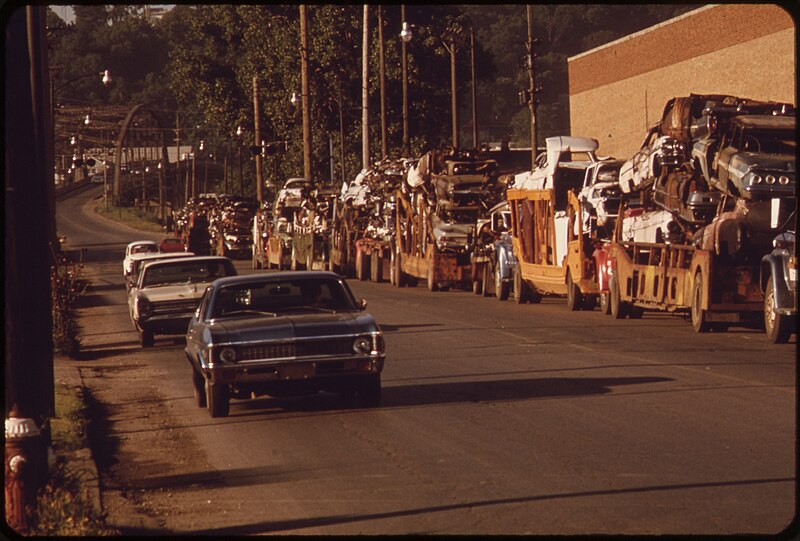
12rh Street in the early morning looking south toward the Kansas River. Junk cars are being sold to a local factory which processes scrap metal: photo by Kenneth Paik (1940-2006) for the Environmental Protection Agency, June 1973 (US National Archives)
![File:AUTOMOBILE JUNKYARD ON THE NORTH BANK OF THE KANSAS RIVER BETWEEN THE 12TH AND 18TH STREET BRIDGES - NARA - 552073.tif]()
Automobile junkyard on the north bank of the Kansas River between the 12th and 18th Street bridges: photo by Kenneth Paik (1940-2006) for the Environmental Protection Agency, May 1973 (US National Archives)
![File:INNER CITY VIADUCT AREA WHERE RAILROAD AND AUTO BRIDGES ACROSS THE MISSOURI RIVER JOIN KANSAS CITY, KS, WITH KANSAS... - NARA - 552064.jpg]()
Inner city viaduct area where railroad and auto bridges across the Missouri River join Kansas City, Kansas with Kansas City, Missouri. This is the point where the Kansas River and the Missouri River come together: photo by Kenneth Paik (1940-2006) for the Environmental Protection Agency, May 1973 (US National Archives)
![File:INDUSTRY, JUST UPSTREAM FROM THE 18TH STREET BRIDGE DISCHARGES WASTE FROM WATER FILTERING PROCESS INTO THE KANSAS RIVER - NARA - 552070.jpg]()
Industry just upstream from the 18th Street bridge discharges waste from water filtering process into the Kansas River, Kansas City: photo by Kenneth Paik (1940-2006) for the Environmental Protection Agency, June 1973 (US National Archives)
![ken_paik04]()
Ken Paik (1940-2006) covers the NAIA Basketball Tournament as a photographer with the Kansas City Star: photo by Dale Monaghen,19 March 1974; posted 27 November 2006 (via Dale Monaghen)
![ken_paik05]()
Ken Paik (1940-2006) covers the NAIA Basketball Tournament as a photographer with the Kansas City Star: photo by Dale Monaghen, 19 March 1974; posted 27 November 2006 (via Dale Monaghen)
![ken_paik03]()
Ken Paik (1940-2006) covers a fire at 12th and Central Ave. in Kansas City, Missouri as a photographer with the Kansas City Star: photo by Dale Monaghen, April 1974; posted 27 November 2006 (via Dale Monaghen)
![ken_paik06]()
Ken Paik (1940-2006) covers the KU Relays in Lawrence, Kansas as a photographer with the Kansas City Star: photo by Dale Monaghen, 19 April 1974; posted 27 November 2006 (via Dale Monaghen)
![ken_paik01]()
Ken Paik (1940-2006) covers the arrival of Vietnamese refugees at Fort Chaffee, Arkansas as a photographer with the Kansas City Star: photo by Dale Monaghen, May 1975; posted 27 November 2006 (via Dale Monaghen)

Residents of Mulky Square, a low-income neighborhood on the city's west side, face large scale displacement by a new interstate highway (I-635). Many houses have been demolished, others stand empty. For the people who remain, life goes on with very little change. On Saturday in a neighborhood tavern, Ernest Watkins of Mulky Square finds his favorite relaxation. Mr. Watkins, father of nine, is a biscuit company worker: photo by Kenneth Paik (1940-2006) for the Environmental Protection Agency, September 1973 (US National Archives)
I...Ernest Watkins

Mulky Square neighbors meet over a beer. This low-income neighborhood faces major disruption with the projected building of a new highway (I-635) through the area: photo by Kenneth Paik (1940-2006) for the Environmental Protection Agency, October 1973 (US National Archives)

Ernest Watkins in his Mulky Square home. Mr. Watkins, father of nine, is a biscuit company worker: photo by Kenneth Paik (1940-2006) for the Environmental Protection Agency, October 1973 (US National Archives)

Ernest Watkins of Mulky Square, biscuit company worker and father of nine, sits on his front doorstep with his three-year-old son: photo by Kenneth Paik (1940-2006) for the Environmental Protection Agency, October 1973 (US National Archives)

Ernest Watkins of Mulky Square, biscuit company worker and father of nine, likes his beer and likes teaching his three-year-old son to like it: photo by Kenneth Paik (1940-2006) for the Environmental Protection Agency, October 1973 (US National Archives)

Ernest Watkins in his Mulky Square home. Mr. Watkins, father of nine, is a biscuit company worker: photo by Kenneth Paik (1940-2006) for the Environmental Protection Agency, October 1973 (US National Archives)

Weekends for this Mulky Square biscuit company worker and father of nine mean beer and sleep. Mulky Square, an area of low income families on the city's west side, is soon to be torn up for a new interstate highway: photo by Kenneth Paik (1940-2006) for the Environmental Protection Agency, October 1973 (US National Archives)
II...May Watkins and Watkins children

Mrs. May Watkins of Mulky Square with her three-year-old son Kevin, one of nine Watkins children: photo by Kenneth Paik (1940-1966) for the Environmental Protection Agency, October 1973 (US National Archives)

Mrs. May Watkins cuddles the youngest of her nine children on the front porch of their of Mulky Square home. This west side neighborhood of low-income families will soon be torn up to make way for a new interstate highway: photo by Kenneth Paik (1940-1966) for the Environmental Protection Agency, October 1973 (US National Archives)

The Watkins of Mulky Square, a family of eleven, live in the 1600 block of Madison Street, a few blocks from the area being cleared for I-95. On the Watkins front porch: Mrs Watkins, her son, daughter-in-law and grandchild: photo by Kenneth Paik (1940-1966) for the Environmental Protection Agency, October 1973 (US National Archives)

A barefoot Mrs. May Watkins (right) sits in her Mulkey Square house with the youngest of her nine children and a daughter-in-law. Much of her time is spent like this. The kitchen in the background badly needs cleaning, but the incentives are lacking: photo by Kenneth Paik (1940-2006) for the Environmental Protection Agency, October 1973 (US National Archives)
Young Kevin Watkins goes to sleep while his nephew (his second brother's son) eats a bowl of cereal on the living room floor. Kevin is one of nine children in a Mulky Square biscuit worker's family: photo by Kenneth Paik (1940-2006) for the Environmental Protection Agency, October 1973 (US National Archives)
Residents of Mulky Square, a low-income neighborhood on the city's west side, face large scale displacement by a new interstate highway (I-635). Many houses have been demolished, others stand empty. For the people who remain, life goes on with very little change, Mrs May Watkins, mother of nine, roughhouses with son Dale and daughter-in-law on the Watkins' front porch: photo by Kenneth Paik (1940-2006) for the Environmental Protection Agency, October 1973 (US National Archives)

Residents of Mulky Square, a low-income neighborhood on the city's west side, face large scale displacement by a new interstate highway (I-635). Many houses have been demolished, others stand empty. For the people who remain, life goes on with very little change. Mrs May Watkins, mother of nine, on the porch of her Mulky Square house: photo by Kenneth Paik (1940-2006) for the Environmental Protection Agency, October 1973 (US National Archives)

Dirty hands of one of the nine children of Mulky Square biscuit worker hold small nephew. In this family love of children is strong but sanitation belongs to a different world. Mulky Square is a low-income area soon to be torn up by a new interstate highway: photo by Kenneth Paik (1940-2006) for the Environmental Protection Agency, October 1973 (US National Archives)

A barefoot Mrs. May Watkins, mother of nine, shares couch in her Mulkey Square living room, Kansas City, with two of her daughters. They find shoes more to their liking: photo by Kenneth Paik (1940-2006) for the Environmental Protection Agency, October 1973 (US National Archives)

Mrs. May Watkins and one of her nine children in the living room of their Mulky Square home, Kansas City. Mrs. Watkins' husband works for a local biscuit company: photo by Kenneth Paik (1940-2006) for the Environmental Protection Agency, October 1973 (US National Archives)

Diane Watkins, one of nine children of a Mulky Square family, eats on the living room couch. The only table in the house is occupied by her 14-year-old sister: photo by Kenneth Paik (1940-2006) for the Environmental Protection Agency, October 1973 (US National Archives)

Diane Watkins, 9, in bedroom of her family's house in Mulky Square. Diane is one of the nine children of a biscuit company worker and his wife. Area soon to be torn up to make way for a new interstate highway (I-635): photo by Kenneth Paik (1940-2006) for the Environmental Protection Agency, October 1973 (US National Archives)

Going to exchange empties for more soda pop in Mulky Square, a low-income neighborhood on the city's west side. Residents face uprooting by a new interstate highway (I-95): photo by Kenneth Paik (1940-2006) for the Environmental Protection Agency, October 1973 (US National Archives)
III...Watkins boys

The Watkins of Mulky Square, a family of eleven, live in the 1600 block of Madison Street, a few blocks from the area being cleared for I-635. The older Watkins boys tinker with cars, a favorite occupation: photo by Kenneth Paik (1940-2006) for the Environmental Protection Agency, October 1973 (US National Archives)

Residents of Mulky Square, a low-income neighborhood on the city's west side, face large scale displacement by a new interstate highway (I-635). Many houses have been demolished, others stand empty. For the people who remain, life goes on with very little change. Mrs May Watkins with the wife of one of her sons on the Watkins' front porch: photo by Kenneth Paik (1940-2006) for the Environmental Protection Agency, October 1973 (US National Archives)
Wife of Dale Watkins, one of nine children of a Mulky Square family, performs a little cosmetic surgery on her husband's face. Mulky Square is a deteriorating neighborhood of low-income famlies, soon to be torn up to make way for a new interstate highway: photo by Kenneth Paik (1940-1966) for the Environmental Protection Agency, October 1973 (US National Archives)

Wife of Dale Watkins, one of nine children of a Mulky Square family, performs a little cosmetic surgery on her husbands's face. Mulky Square is a deteriorating neighborhood of low-income famlies, soon to be torn up to make way for a new interstate highway: photo by Kenneth Paik (1940-1966) for the Environmental Protection Agency, October 1973 (US National Archives)

Doodles of Dale Watkins, one of nine children in a Mulky Square biscuit worker's family. An isolated, poor and deteriorating neighborhood, Mulky Square faces major disruption from a new interstate highway: photo by Kenneth Paik (1940-2006): photo by Kenneth Paik (1940-2006) for the Environmental Protection Agency, October 1973 (US National Archives)

Billy and Sandy Watkins call to a friend on the street from the doorway of their Mulkey Square home, Kansas City: photo by Kenneth Paik (1940-2006) for the Environmental Protection Agency, October 1973 (US National Archives)

Billy Watkins, one of nine children in a biscuit worker's family, broods on the stairs of their Mulky Square house: photo by Kenneth Paik (1940-2006) for the Environmental Protection Agency, October 1973 (US National Archives)

Billy Watkins eats a bowl of cereal in the living room of his house in Mulky Square, Kansas City, Billy is one of nine children of a biscuit company worker and his wife: photo by Kenneth Paik (1940-2006) for the Environmental Protection Agency, October 1973 (US National Archives)

Look, Ma, one wheel. Billy Watkins of Mulkey Square, Kansas City, can ride like this for a whole block, and has even offered to teach others the trick for a small fee -- but so far has found no takers: photo by Kenneth Paik (1940-2006) for the Environmental Protection Agency, September 1973 (US National Archives)
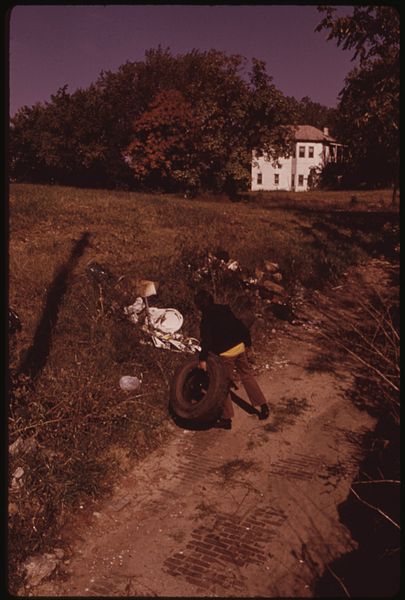
Residents of Mulky Square, a low-income neighborhood on the city's west side, face large scale displacement by a new interstate highway (I-635). Many houses have been demolished, others stand empty. For the people who remain, life goes on with very little change. Billy Watkins plays with an old tire in a cleared-out section now used as a dump. Billy, one of nine children in a biscuit worker's family, doesn't go to school and has a lot of time to kill: photo by Kenneth Paik (1940-2006) for the Environmental Protection Agency, October 1973 (US National Archives)
Residents of Mulky Square, a low-income neighborhood on the city's west side, face large scale displacement by a new interstate highway (I-635). Many houses have been demolished, others stand empty. For the people who remain, life goes on with very little change. Billy Watkins, one of nine children in a biscuit worker's family, passes a run-down apartment building on his way home. The tenants have gone, the building is closed: photo by Kenneth Paik (1940-2006) for the Environmental Protection Agency, October 1973 (US National Archives)
Residents of Mulky Square, a low-income neighborhood on the city's west side, face large scale displacement by a new interstate highway (I-635). Many houses have been demolished, others stand empty. For the people who remain, life goes on with very little change. Billy Watkins, one of nine children in a biscuit worker's family, passes through a now-deserted section of the neighborhood. Billy does not go to school and much of each day is spent "killing time": photo by Kenneth Paik (1940-2006) for the Environmental Protection Agency, October 1973 (US National Archives)
IV...Mulky Square kids
![File:MULKY SQUARE CHILD LOOKS OUT OF SCREEN DOOR ON A RAINY DAY HIS FAMILY OCCUPIES PART OF A BUILDING THAT WILL SOON BE... - NARA - 553554.jpg]()
Mulky Square child looks out of a screen door on a rainy day. His family occupies part of a building that will soon be razed to make way for a new interstate highway (I-635). Many other houses on the street have already been abandoned: photo by Kenneth Paik (1940-1966) for the Environmental Protection Agency, September 1973 (US National Archives)
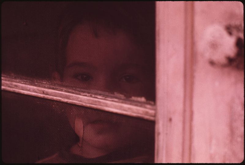
Mulky Square child looks out of a screen door on a rainy day. His family occupies part of a building that will soon be razed to make way for a new interstate highway (I-635). Many other houses on the street have already been abandoned: photo by Kenneth Paik (1940-1966) for the Environmental Protection Agency, September 1973 (US National Archives)

Mulky Square, an isolated, low-income area on the city's west side, is soon to be torn up to make way for a new interstate highway. Many houses stand vacant. A part of this building is still occupied by a family. Their children play around the building: photo by Kenneth Paik (1940-1966) for the Environmental Protection Agency, September 1973 (US National Archives)
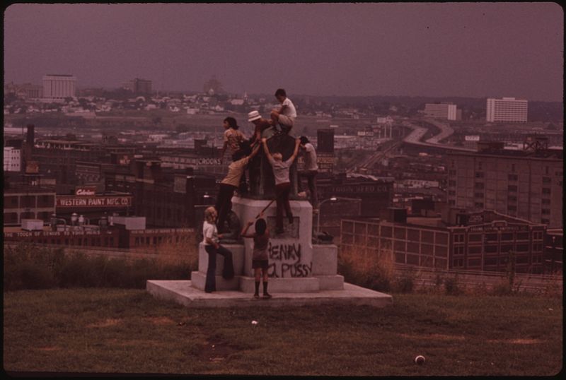
Looking over the "West Bottoms" of Kansas City from Mulky Square Park, a city facility. Park monument makes good climbing: photo by Kenneth Paik (1940-2006) for the Environmental Protection Agency, September 1973 (US National Archives)
Playing football at Mulky Square Park, a city facility: photo by Kenneth Paik (1940-1966) for the Environmental Protection Agency, September 1973 (US National Archives)

Mulky Square area children playing in roadside trash. Within five blocks of the area are a park and recreation area provided by the city: photo by Kenneth Paik (1940-2006) for the Environmental Protection Agency, September 1973 (US National Archives)

Mulky Square youth with cowboy gear and transistor: photo by Kenneth Paik (1940-2006) for the Environmental Protection Agency, September 1973 (US National Archives)
Residents of Mulky Square, a low-income neighborhood on the city's west side, face large scale displacement by a new interstate highway (I-635). Many houses have been demolished, others stand empty. For the people who remain, life goes on with very little change. For neighborhood children, go-cart races are still big weekend fun: photo by Kenneth Paik (1940-2006) for the Environmental Protection Agency's Documerica project, October 1973 (US National Archives)

Children play in Mulky Square, a low income area soon to be torn up to make way for a new interstate highway: photo by Kenneth Paik (1940-2006) for the Environmental Protection Agency, October 1973 (US National Archives)

Mulky Square youngsters show off their tattoos -- everybody has them. "It don't hurt," they assure the photographer: photo by Kenneth Paik (1940-2006) for the Environmental Protection Agency, September 1973 (US National Archives)

Mulky Square girl offers her raccoon, but it still isn't good enough to win her a place in the gang: photo by Kenneth Paik (1940-2006) for the Environmental Protection Agency, September 1973 (US National Archives)

Harold, a Mulkey Square boy who says that he spent a year at the Missouri Boys' Reformatory in Boonville, shows off his smoking style and his tattoos. Younger boys accept Harold as a natural leader: photo by Kenneth Paik (1940-2006) for the Environmental Protection Agency, October 1973 (US National Archives)
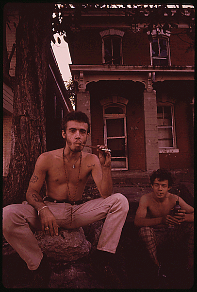
Mulky Square is a neighborhood on the west side of Kansas City, an area of low-income dwellings. I-635 will cut right through Mulky Square, which is already isolated by railroad yards on the west, I-70 on the north and I-35 plus a 4-lane freeway on the east. Buildings are being closed down. These brothers talk about moving to California as they sit on the steps of an already abandoned house on the 1600 block of Madison Street outside the area being cleared for I-635: photo by Kenneth Paik (1940-2006): photo by Kenneth Paik (1940-2006) for the Environmental Protection Agency, October 1973 (US National Archives)

Mulky Square boy walks past a building marked for demolition to make way for a new interstate highway (I-635). The building of the road through the area means large-scale displacement for the residents: photo by Kenneth Paik (1940-2006) for the Environmental Protection Agency, October 1973 (US National Archives)
V...Vulnerability -- the elderly

Elderly resident of Mulky Square must soon find new lodging. Her present home is in the path of I-635: photo by Kenneth Paik (1940-2006): photo by Kenneth Paik (1940-2006) for the Environmental Protection Agency, October 1973 (US National Archives)

Mulky Square is a neighborhood in the west side of Kansas City, an area of low-income dwellings. I-635 will cut right through Mulky Square, which is already isolated by railroad yards on the west, I-70 on the north plus a 4-lane freeway on the east. This building in the West 700 block of 16th street is coming down. Finding other housing for the same rent is a problem: photo by Kenneth Paik (1940-1966) for the Environmental Protection Agency, October 1973 (US National Archives)
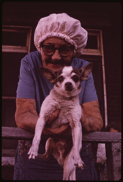
Mulky Square is a neighborhood in the west side of Kansas City, an area of low-income dwellings. I-635 will cut right through Mulky Square, which is already isolated by railroad yards on the west, I-70 on the north plus a 4-lane freeway on the east. This elderly woman, living on social security, must find other lodging because her present home is in the path of I-635: photo by Kenneth Paik (1940-1966) for the Environmental Protection Agency, October 1973 (US National Archives)

Elderly residents of this building in the West 700 block of 16th Street in Mulky Square must find other lodging soon. Their present home is in the path of I-635: photo by Kenneth Paik (1940-2006): photo by Kenneth Paik (1940-2006) for the Environmental Protection Agency, October 1973 (US National Archives)
Elderly residents of this building in the West 700 block of 16th Street in Mulky Square must find other lodging soon. Their present home is in the path of I-635: photo by Kenneth Paik (1940-2006): photo by Kenneth Paik (1940-2006) for the Environmental Protection Agency, October 1973 (US National Archives)

Elderly residents of this building in the West 700 block of 16th Street in Mulky Square must find other lodging soon. Their present home is in the path of I-635: photo by Kenneth Paik (1940-2006): photo by Kenneth Paik (1940-2006) for the Environmental Protection Agency, October 1973 (US National Archives)

Mulky Square is a neighborhood in the west side of Kansas City, an area of low-income dwellings. I-635 will cut right through Mulky Square, which is already isolated by railroad yards on the west, I-70 on the north plus a 4-lane freeway on the east. Looking east toward downtown. Area in foreground was cleared for I-635: photo by Kenneth Paik (1940-1966) for the Environmental Protection Agency, October 1973 (US National Archives)

Mulky Square is a neighborhood in the west side of Kansas City, an area of low-income dwellings. I-635 will cut right through Mulky Square, which is already isolated by railroad yards on the west, I-70 on the north plus a 4-lane freeway on the east. I-635 will extend westward from this point: photo by Kenneth Paik (1940-1966) for the Environmental Protection Agency, October 1973 (US National Archives)

Mulky Square is a neighborhood in the west side of Kansas City, an area of low-income dwellings. I-635 will cut right through Mulky Square, which is already isolated by railroad yards on the west, I-70 on the north plus a 4-lane freeway on the east. Looking east toward downtown: photo by Kenneth Paik (1940-1966) for the Environmental Protection Agency, October 1973 (US National Archives)

Mulky Square is a neighborhood in the west side of Kansas City, an area of low-income dwellings. I-635 will cut right through Mulky Square, which is already isolated by railroad yards on the west, I-70 on the north plus a 4-lane freeway on the east. I-635 will extend westward from this point. A resident returns from downtown by the 14th Street bridge, the only connection for people north of 23rd Street: photo by Kenneth Paik (1940-1966) for the Environmental Protection Agency, October 1973 (US National Archives)

Mulky Square is a neighborhood in the west side of Kansas City, an area of low-income dwellings. I-635 will cut right through Mulky Square, which is already isolated by railroad yards on the west, I-70 on the north plus a 4-lane freeway on the east. On Madison Street, above the area cleared for I-635, some businesses and residents plan to stay on: photo by Kenneth Paik (1940-1966) for the Environmental Protection Agency, October 1973 (US National Archives)

A couple of older residents of Mulky Square move down an empty street. The place where these men are standing will soon be part of a new interstate highway. About five blocks away (background) is the downtown area: photo by Kenneth Paik (1940-1966) for the Environmental Protection Agency, September 1973 (US National Archives)
VI...Demolition and Abandonment

Member of a wrecking crew rests during demolition of hosing in the Mulkey Square area. Many of the low income residents living there were displaced by construction of an interstate highway through an area already isolated by roads and railroad tracks. It took one such family two months to find rental housing within their price range on the other side of town in Kansas City, Kansas. Moving was traumatic for many of the families: photo by Kenneth Paik (1940-1966) for the Environmental Protection Agency, May 1973 (US National Archives)

Mulky Square is a neighborhood in the west side of Kansas City, an area of low-income dwellings. I-635 will cut right through Mulky Square, which is already isolated by railroad yards on the west, I-70 on the north plus a 4-lane freeway on the east. Clearing for I-635: photo by Kenneth Paik (1940-1966) for the Environmental Protection Agency, October 1973 (US National Archives)

Mulky Square is a neighborhood in the west side of Kansas City, an area of low-income dwellings. I-635 will cut right through Mulky Square, which is already isolated by railroad yards on the west, I-70 on the north plus a 4-lane freeway on the east. Billy Watkins watches an apartment building come down in the 1600 block of Madison Street: photo by Kenneth Paik (1940-1966) for the Environmental Protection Agency, October 1973 (US National Archives)
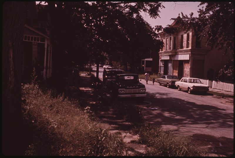
Mulky Square houses, vacant now because they stand in the path of a new interstate highway (I-635). Mulky Square is an isolated west side neighborhood of low-income families. The highway means disruption on a major scale: photo by Kenneth Paik (1940-1966) for the Environmental Protection Agency, September 1973 (US National Archives)

Mulky Square houses, vacant now because they stand in the path of a new interstate highway (I-635). Mulky Square is an isolated west side neighborhood of low-income families. The highway means disruption on a major scale: photo by Kenneth Paik (1940-1966) for the Environmental Protection Agency, September 1973 (US National Archives)

Mulky Square is a neighborhood in the west side of Kansas City, an area of low-income dwellings. I-635 will cut right through Mulky Square, which is already isolated by railroad yards on the west, I-70 on the north plus a 4-lane freeway on the east. Boarded-up building on Summit Street: photo by Kenneth Paik (1940-1966) for the Environmental Protection Agency, October 1973 (US National Archives)
Mulky Square is a neighborhood on the west side of Kansas City, an area of low-income dwellings. I-635 will cut right through Mulky Square, which is already isolated by railroad yards on the west, I-70 on the north and I-35 plus a 4-lane freeway on the east. Buildings are being closed down: photo by Kenneth Paik (1940-2006) for the Environmental Protection Agency, October 1973 (US National Archives)
Mulky Square, an isolated, low-income area on the city's west side, is soon to be torn up to make way for a new interstate highway. Many houses stand vacant. A part of this building is still occupied by a family: photo by Kenneth Paik (1940-1966) for the Environmental Protection Agency, September 1973 (US National Archives)
VII...Junkyard America: In a broken doll's eyes
The owner of this huge junk shop on the Kansas River in Bonner Springs died in 1971. Now there is only the river and the junk; each day the river claims a small part: photo by Kenneth Paik (1940-2006) for the Environmental Protection Agency, June 1973 (US National Archives)
Time Lapse
Each day, a
small part
of a whole lot
of yesterday
twilight
in the whites
of the broken
doll's eyes
A broken doll's face by the river edge -- silent commentary on man's use of nature as a junkyard. Near the 7th street bridge on the Kansas River, Kansas City: photo by Kenneth Paik (1940-2006) for the Environmental Protection Agency, October 1973; image by Queeg, October 2011 (US National Archives)

A broken doll's face by the river edge -- silent commentary on man's use of nature as a junkyard. Near the 7th street bridge on the Kansas River, Kansas City: photo by Kenneth Paik (1940-2006) for the Environmental Protection Agency, October 1973 (US National Archives)
VIII...Now there is only the river and the junk

The owner of this huge junk shop on the Kansas River in Bonner Springs died in 1971. Now there is only the river and the junk; each day the river claims a small part: photo by Kenneth Paik (1940-2006) for the Environmental Protection Agency, June 1973 (US National Archives)
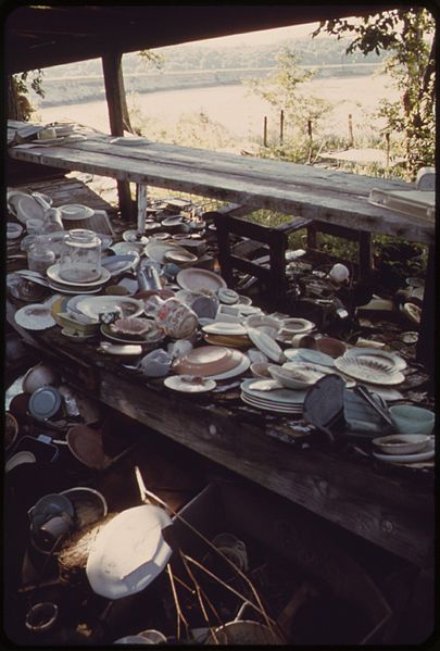
The owner of this huge junk shop on the Kansas River in Bonner Springs died in 1971. Now there is only the river and the junk; each day the river claims a small part: photo by Kenneth Paik (1940-2006) for the Environmental Protection Agency, June 1973 (US National Archives)
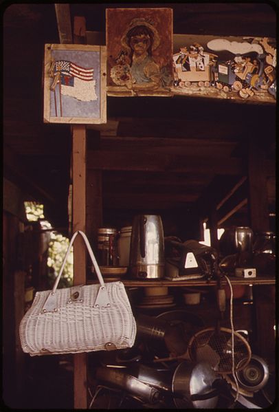
The owner of this huge junk shop on the Kansas River in Bonner Springs died in 1971. Now there is only the river and the junk; each day the river claims a small part: photo by Kenneth Paik (1940-2006) for the Environmental Protection Agency, June 1973 (US National Archives)

The owner of this huge junk shop on the Kansas River in Bonner Springs died in 1971. Now there is only the river and the junk; each day the river claims a small part: photo by Kenneth Paik (1940-2006) for the Environmental Protection Agency, June 1973 (US National Archives)

The owner of this huge junk shop on the Kansas River in Bonner Springs died in 1971. Now there is only the river and the junk; each day the river claims a small part: photo by Kenneth Paik (1940-2006) for the Environmental Protection Agency, June 1973 (US National Archives)

The owner of this huge junk shop on the Kansas River in Bonner Springs died in 1971. Now there is only the river and the junk; each day the river claims a small part: photo by Kenneth Paik (1940-2006) for the Environmental Protection Agency, June 1973 (US National Archives)

The owner of this huge junk shop on the Kansas River in Bonner Springs died in 1971. Now there is only the river and the junk; each day the river claims a small part: photo by Kenneth Paik (1940-2006) for the Environmental Protection Agency, June 1973 (US National Archives)

The owner of this huge junk shop on the Kansas River in Bonner Springs died in 1971. Now there is only the river and the junk; each day the river claims a small part: photo by Kenneth Paik (1940-2006) for the Environmental Protection Agency, June 1973 (US National Archives)

The owner of this huge junk shop on the Kansas River in Bonner Springs died in 1971. Now there is only the river and the junk; each day the river claims a small part: photo by Kenneth Paik (1940-2006) for the Environmental Protection Agency, June 1973 (US National Archives)

The owner of this huge junk shop on the Kansas River in Bonner Springs died in 1971. Now there is only the river and the junk; each day the river claims a small part: photo by Kenneth Paik (1940-2006) for the Environmental Protection Agency, June 1973 (US National Archives)
12rh Street in the early morning looking south toward the Kansas River. Junk cars are being sold to a local factory which processes scrap metal: photo by Kenneth Paik (1940-2006) for the Environmental Protection Agency, June 1973 (US National Archives)

Automobile junkyard on the north bank of the Kansas River between the 12th and 18th Street bridges: photo by Kenneth Paik (1940-2006) for the Environmental Protection Agency, May 1973 (US National Archives)

Inner city viaduct area where railroad and auto bridges across the Missouri River join Kansas City, Kansas with Kansas City, Missouri. This is the point where the Kansas River and the Missouri River come together: photo by Kenneth Paik (1940-2006) for the Environmental Protection Agency, May 1973 (US National Archives)

Industry just upstream from the 18th Street bridge discharges waste from water filtering process into the Kansas River, Kansas City: photo by Kenneth Paik (1940-2006) for the Environmental Protection Agency, June 1973 (US National Archives)
The photographer

Ken Paik (1940-2006) covers the NAIA Basketball Tournament as a photographer with the Kansas City Star: photo by Dale Monaghen,19 March 1974; posted 27 November 2006 (via Dale Monaghen)

Ken Paik (1940-2006) covers the NAIA Basketball Tournament as a photographer with the Kansas City Star: photo by Dale Monaghen, 19 March 1974; posted 27 November 2006 (via Dale Monaghen)

Ken Paik (1940-2006) covers a fire at 12th and Central Ave. in Kansas City, Missouri as a photographer with the Kansas City Star: photo by Dale Monaghen, April 1974; posted 27 November 2006 (via Dale Monaghen)


Ken Paik (1940-2006) covers the arrival of Vietnamese refugees at Fort Chaffee, Arkansas as a photographer with the Kansas City Star: photo by Dale Monaghen, May 1975; posted 27 November 2006 (via Dale Monaghen)


