.

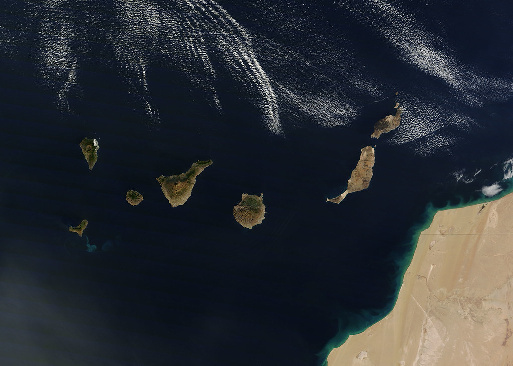
Canary Islands. The rugged landscape of the Canary Islands stood out in sharp contrast to the smooth blue waters of the Atlantic Ocean and the flat tan land of northwestern Africa on 21 December 2011, when the Moderate Resolution Imaging Spectroradiometer (MODIS) aboard the Terra satellite captured this true-color image. The Canary Islands are a group of seven large islands and several smaller islets, all volcanic in origin. The eastern edge of the chain lies only 100 kilometers from the coasts of Morocco and Western Sahara, and the chain stretches for about 500 kilometers across theAtlantic. All the islands are mountainous, and Tenerife, the central island in this image is home to Pico de Teinde, the highest peak, which rises 12,198 feet (3,718 meters) above sea level. From east to west, the islands are named Lanzarote, Fuerteventura, Gran Canaria, Tenerife, La Gomera, La Palmera and El Hierro. A bright swirl of peacock blue marks the ocean south of El Hierro, a stain on the sea from an ongoing eruption of a volcano under the waters: image by NASA/GSFC/Jeff Schmaltz/MODIS Land Rapid Response Team (NASA)
Do not try to adopt me
I am not a pigmy soothed
Boy or baby hitchhiker saint
What is wrong suddenly
Is that I swallow a cold
Blast of air, I mean fright
Spill coffee on my book
And hear the kinks
In the great universe
Thewarp in the coffin
Phantom men fly out of
Anywhere in this world
I am not a pigmy soothed
Boy or baby hitchhiker saint
What is wrong suddenly
Is that I swallow a cold
Blast of air, I mean fright
Spill coffee on my book
And hear the kinks
In the great universe
Thewarp in the coffin
Phantom men fly out of
Anywhere in this world
(1965)

Aerial view of Pico do Fogo, a volcano on Cabo Verde, showing the volcano's nine-kilometre-wide caldera, Cha Caldera.The crater wall in the west towers one kilometre above the crater floor. The eastern half of the crater wall is gone, erased in a massive collapse deep in its ancient history. Evidence of the volcano’s more recent eruptive history is written on the surface of the crater as well. In the centre of the crater, a steep cone named Pico rises about 100 meters above the crater rim (more than a kilometre from the crater floor). The young peak reaches 2,829 meters above sea level, making it the island’s highest point. Dark trails of hardened lava from the volcano's most recent eruptions stream out of the crater east into the Atlantic Ocean. The volcano last erupted in 1995. The sepia stream of lava from that eruption is pooled near the crater rim west of Pico. Remarkably, the crater is inhabited. A straight road cuts between the crater wall and Pico, ending near the vent that erupted in 1995. Bright white dots on the north side of the crater are villages. Residents of the Cha Caldera evacuated during the eruption: image by Jesse Allen for NASA Earth Observatory, 10 June 2009 (NASA)
Iolanda Reef, Ras Muhammad Nature Park: photo by Mikhail Rogov, 7 February 2006

Water islands: image by @Doug88888, 4 September 2011
