.
![]()
![]()
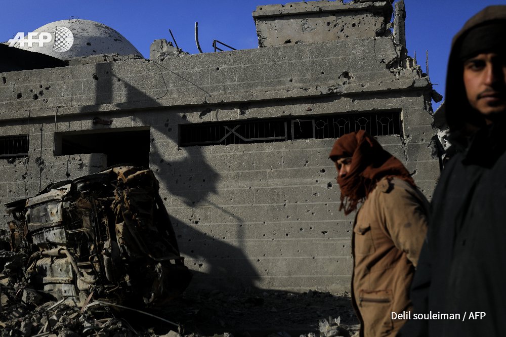
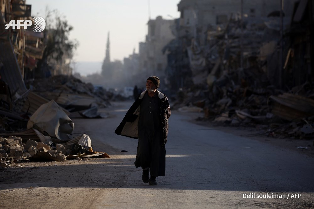
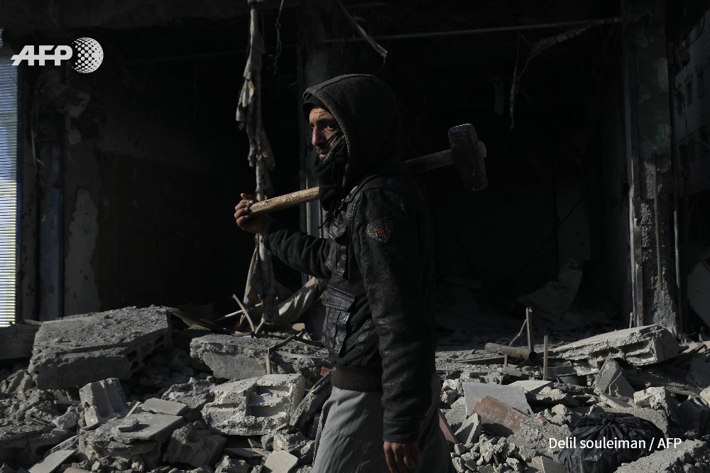
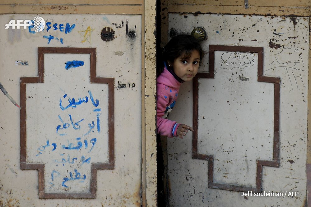
#Syria Scenes from #Raqa, the former "capital" of the Islamic State (IS) group in Syria. Photo @Delilsouleman: image via Frédérique Geffard @fgeffardAFP, 12 January 2018
![]()
#Syria Scenes from #Raqa, the former "capital" of the Islamic State (IS) group in Syria. Photo @Delilsouleman: image via Frédérique Geffard @fgeffardAFP, 12 January 2018
![]()
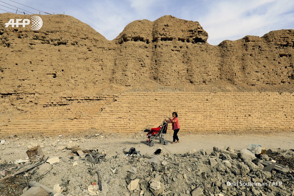
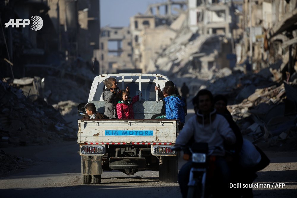
Today in #Raqqa city: image via Delilsouleman @Delilsouleman, 11 January 2018
![]()
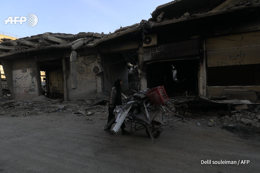
SYRIA - A woman pulls a cart loaded with pieces of metal in Syria's devastated city of Raqa.Photo @Delilsouleman: image via Frédérique Geffard @fgeffardAFP, 10 January 2018
![]()
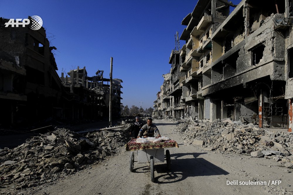
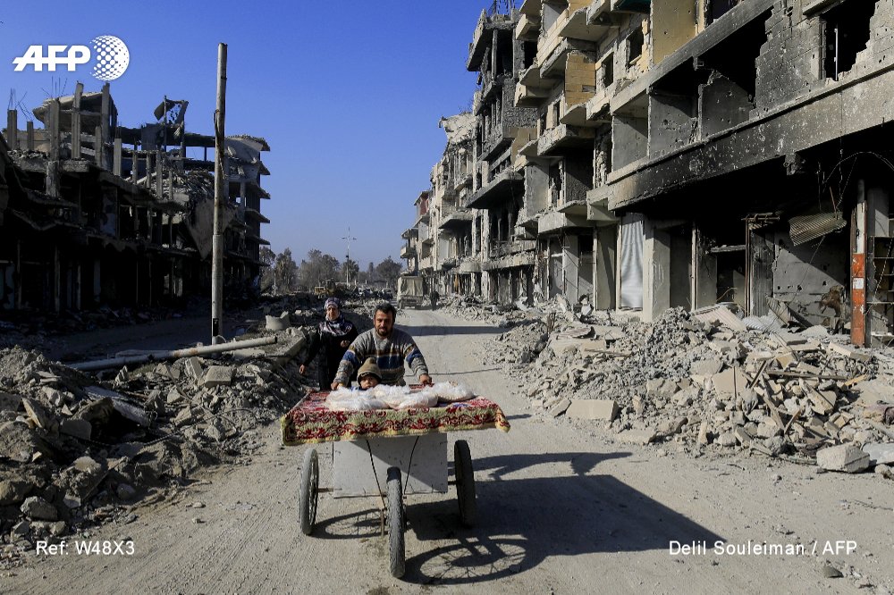
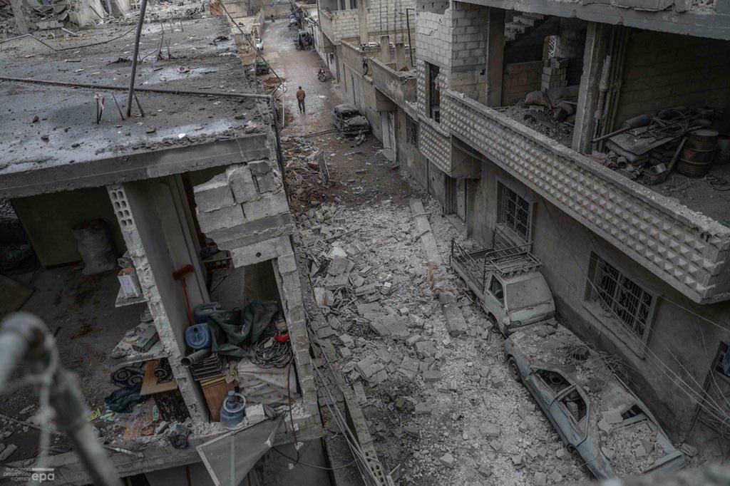
City of #Raqa on January 9, 2018. Photo DELIL SOULEIMAN / #AFP: image via Delilsouleman @Delilsouleman, 9 January 2018
![]()
City of #Raqa on January 9, 2018. Photo DELIL SOULEIMAN / #AFP: image via Delilsouleman @Delilsouleman, 9 January 2018
![]()
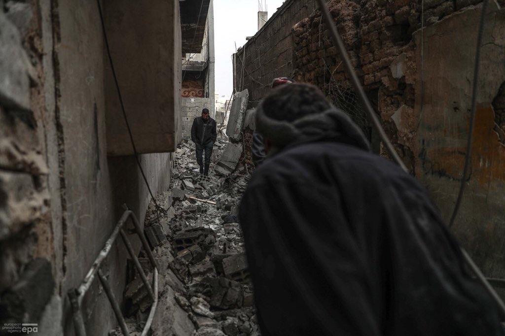
City of #Raqa on January 9, 2018. Photo DELIL SOULEIMAN / #AFP: image via Delilsouleman @Delilsouleman, 9 January 2018
![]()
City of #Raqa on January 9, 2018. Photo DELIL SOULEIMAN / #AFP: image via Delilsouleman @Delilsouleman, 9 January 2018
![]()
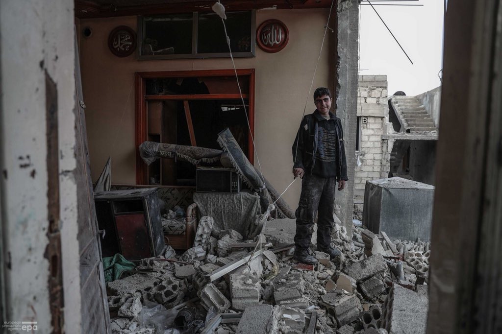
City of #Raqa on January 9, 2018. Photo DELIL SOULEIMAN / #AFP: image via Delilsouleman @Delilsouleman, 9 January 2018
![]()
City of #Raqa on January 9, 2018. Photo DELIL SOULEIMAN / #AFP: image via Delilsouleman @Delilsouleman, 9 January 2018
![]()
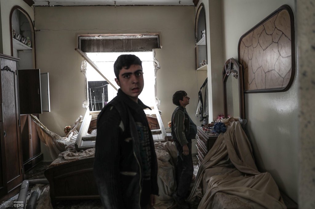
City of #Raqa on January 9, 2018. Photo DELIL SOULEIMAN / #AFP: image via Delilsouleman @Delilsouleman, 9 January 2018
![]()
SYRIA - A man pulls a cart in Syria's devastated city of Raqa.Photo @Delilsouleman: image via Frédérique Geffard @fgeffardAFP, 10 January 2018
![]()
City of #Raqa on January 9, 2018. Photo DELIL SOULEIMAN / #AFP: image via Delilsouleman @Delilsouleman, 9 January 2018
![]()
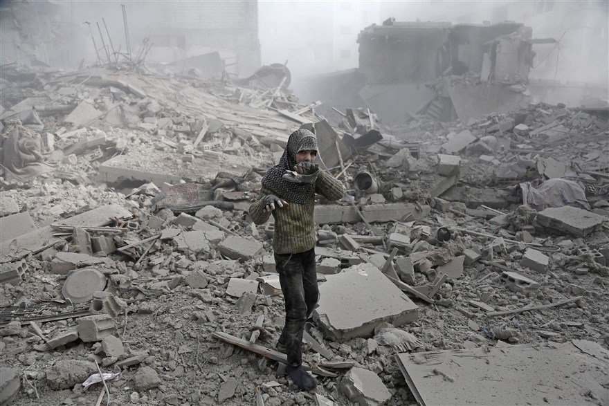
An airstrike on Kafr Battikh village in Idlib province killed 14 people on 13 January.: photo by Anadolu Agency/Getty Images, 13 January 2018
![]()
This is a part of the most powerful pictures in the world for last week, all of them taken following airstrikes by the Syrian government forces on the besieged Eastern Ghouta near the Syrian capital Damascus. PHOTO By: ABDULMONAM EASSA Via / #AFP: image via Abdulmonam Eassa @abdfree2, 12 January 2018
![]()
![]()
![]()
![]()
![]()
![]()
![]()
![]()
![]()
GAZA CITY - Palestinian protesters clash with Israeli security forces on the eastern outskirts of Gaza City, near the border with Israel. Photo @mohmdabed #AFP: image via Frédérique Geffard @fgeffardAFP, 12 January 2018
![]()
![]()
it’s placed on.
Nothing moves beneath it
and it seeks no outlet.
Above -- my human breath
creates no stirring air
and leaves its total surface
undisturbed.
Its plains, valleys are always green,
uplands, mountains are yellow and brown,
while seas, oceans remain a kindly blue
beside the tattered shores.
Everything here is small, near, accessible.
I can press volcanoes with my fingertip,
stroke the poles without thick mittens,
I can with a single glance
encompass every desert
with the river lying just beside it.
A few trees stand for ancient forests,
you couldn’t lose your way among them.
In the east and west,
above and below the equator --
quiet like pins dropping,
and in every black pinprick
people keep on living.
Mass graves and sudden ruins
are out of the picture.
Nations’ borders are barely visible
as if they wavered -- to be or not.
I like maps, because they lie.
Because they give no access to the vicious truth.
Because great-heartedly, good-naturedly
they spread before me a world
not of this world.
Wislawa Szymborska (1923-2012): Map, 2012, translated by Clare Cavanagh in Map: Collected and Last Poems, 2015
![]()
Map of Tuscany and the Chiana Valley: Leonardo da Vinci, c.1502, black chalk, pen, ink and colour on paper, 338 x 488 mm (Royal Library, Windsor)
![]()
Heart-shaped Map: Oronce Finé, 1536, engraving, watercolour, 51 x 57 cm (Bibliothèque Nationale, Paris) ![]()
![Embedded image permalink]()
![]()
World Map: Benedetto Bordone, 1528, woodcut, 325 x 165 mm (British Library, London)
![]()
Lion Map (Leo Belgicus): Claes Jansz Visscher the Younger, 1609, coloured etching and engraving, 470 x 572 mm (Stichting Atlas van Stolk, Rotterdam) ![]()
Image of the Pilgrimage of St Paul: Abraham Ortelius, 1579, engraving
![[synthetica.jpg]]()
Synthetica: A New Continent of Plastic: Union Carbide and Carbon Corporation advertisement for plastics, Fortune, October 1940 (Gallery of Graphic Design) ![Embedded image permalink]()
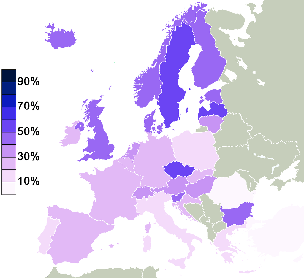
Percentage of non religious people in Europe that agreed to the statement "there is some sort of spirit life force": image via Amazing Maps @Amazing_Maps, 21 August 2015 ![]()
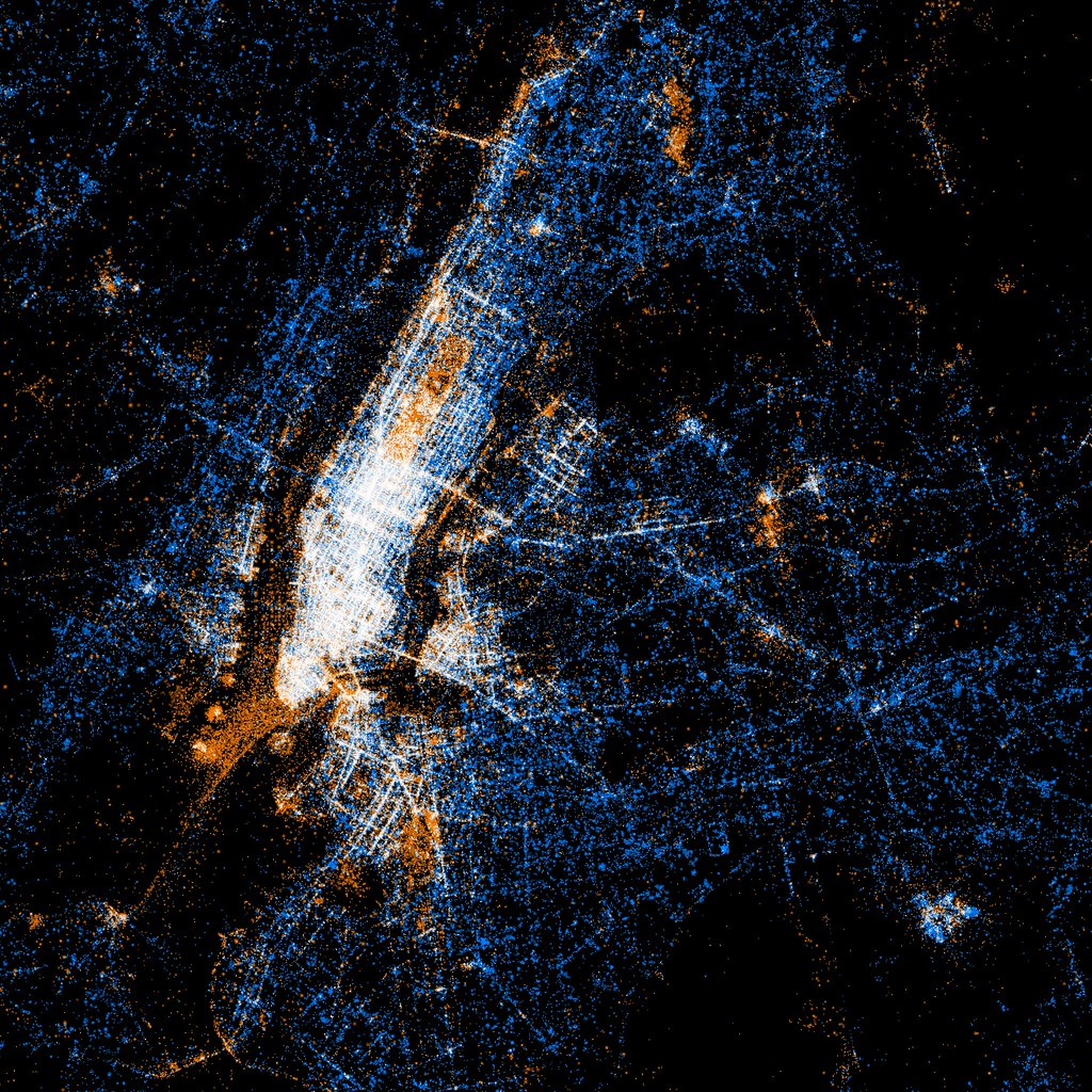
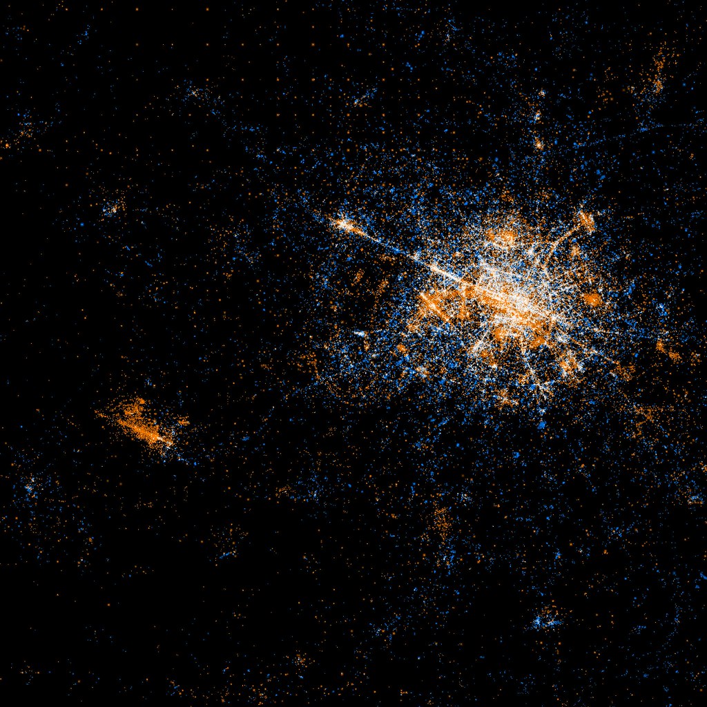
New York: map of Flickr and Twitter locations. Red dots are locations of Flickr pictures. Blue dots are locations of Twitter tweets. White dots are locations that have been posted to both: image by Eric Fischer (See something or say something), 7 July 2011
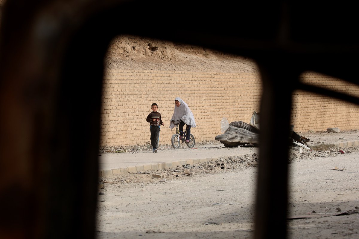
SYRIA - A girl plays in Raqa, the former "capital" of the Islamic State (IS) group in Syria. Photo @Delilsouleman #AFP: image via Frédérique Geffard @fgeffardAFP, 12 January 2018
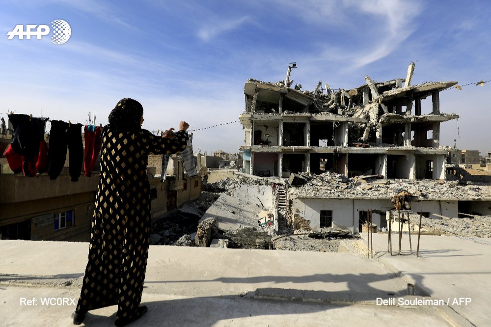
#Syria Scenes from #Raqa, the former "capital" of the Islamic State (IS) group in Syria. Photo @Delilsouleman: image via Frédérique Geffard @fgeffardAFP, 12 January 2018
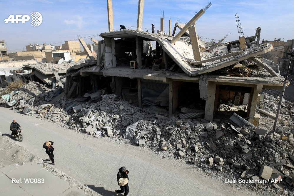
#Syria Scenes from #Raqa, the former "capital" of the Islamic State (IS) group in Syria. Photo @Delilsouleman: image via Frédérique Geffard @fgeffardAFP, 12 January 2018
Today in #Raqqa city: image via Delilsouleman @Delilsouleman, 11 January 2018
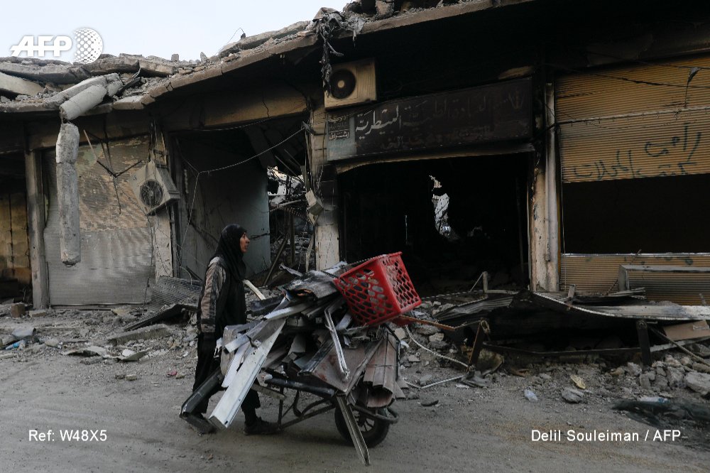
SYRIA - A woman pulls a cart loaded with pieces of metal in Syria's devastated city of Raqa.Photo @Delilsouleman: image via Frédérique Geffard @fgeffardAFP, 10 January 2018
City of #Raqa on January 9, 2018. Photo DELIL SOULEIMAN / #AFP: image via Delilsouleman @Delilsouleman, 9 January 2018
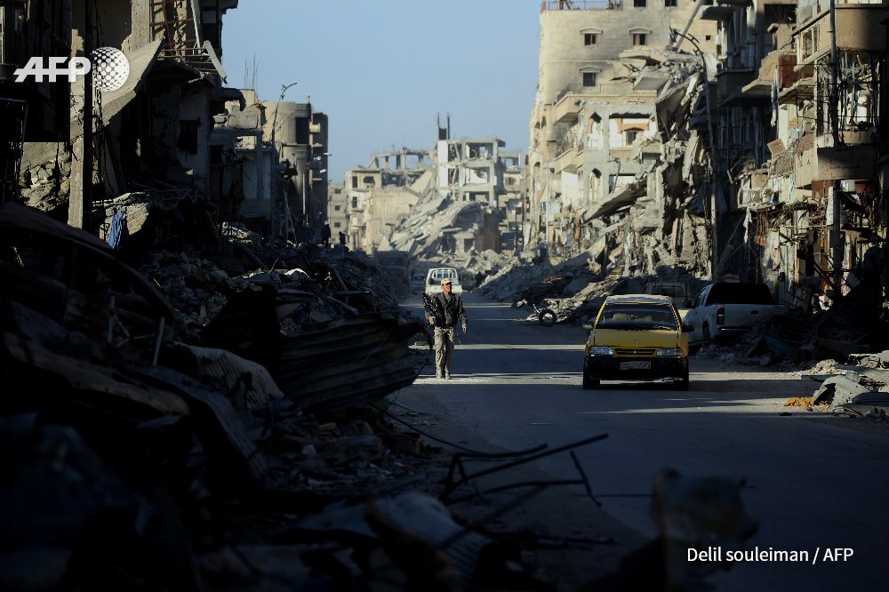
City of #Raqa on January 9, 2018. Photo DELIL SOULEIMAN / #AFP: image via Delilsouleman @Delilsouleman, 9 January 2018
City of #Raqa on January 9, 2018. Photo DELIL SOULEIMAN / #AFP: image via Delilsouleman @Delilsouleman, 9 January 2018
City of #Raqa on January 9, 2018. Photo DELIL SOULEIMAN / #AFP: image via Delilsouleman @Delilsouleman, 9 January 2018
City of #Raqa on January 9, 2018. Photo DELIL SOULEIMAN / #AFP: image via Delilsouleman @Delilsouleman, 9 January 2018
City of #Raqa on January 9, 2018. Photo DELIL SOULEIMAN / #AFP: image via Delilsouleman @Delilsouleman, 9 January 2018
City of #Raqa on January 9, 2018. Photo DELIL SOULEIMAN / #AFP: image via Delilsouleman @Delilsouleman, 9 January 2018
SYRIA - A man pulls a cart in Syria's devastated city of Raqa.Photo @Delilsouleman: image via Frédérique Geffard @fgeffardAFP, 10 January 2018
City of #Raqa on January 9, 2018. Photo DELIL SOULEIMAN / #AFP: image via Delilsouleman @Delilsouleman, 9 January 2018
An airstrike on Kafr Battikh village in Idlib province killed 14 people on 13 January.: photo by Anadolu Agency/Getty Images, 13 January 2018
This is a part of the most powerful pictures in the world for last week, all of them taken following airstrikes by the Syrian government forces on the besieged Eastern Ghouta near the Syrian capital Damascus. PHOTO By: ABDULMONAM EASSA Via / #AFP: image via Abdulmonam Eassa @abdfree2, 12 January 2018
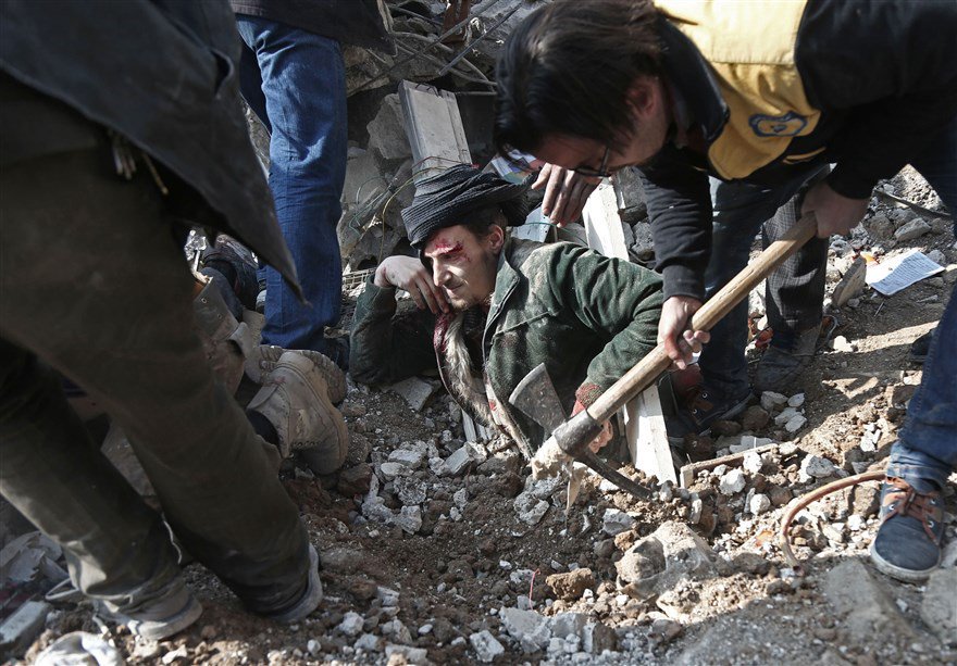
This is a part of the most powerful pictures in the world for last week, all of them taken following airstrikes by the Syrian government forces on the besieged Eastern Ghouta near the Syrian capital Damascus. PHOTO By: ABDULMONAM EASSA Via / #AFP: image via Abdulmonam Eassa @abdfree2, 12 January 2018
This is a part of the most powerful pictures in the world for last week, all of them taken following airstrikes by the Syrian government forces on the besieged Eastern Ghouta near the Syrian capital Damascus. PHOTO By: ABDULMONAM EASSA Via / #AFP: image via Abdulmonam Eassa @abdfree2, 12 January 2018

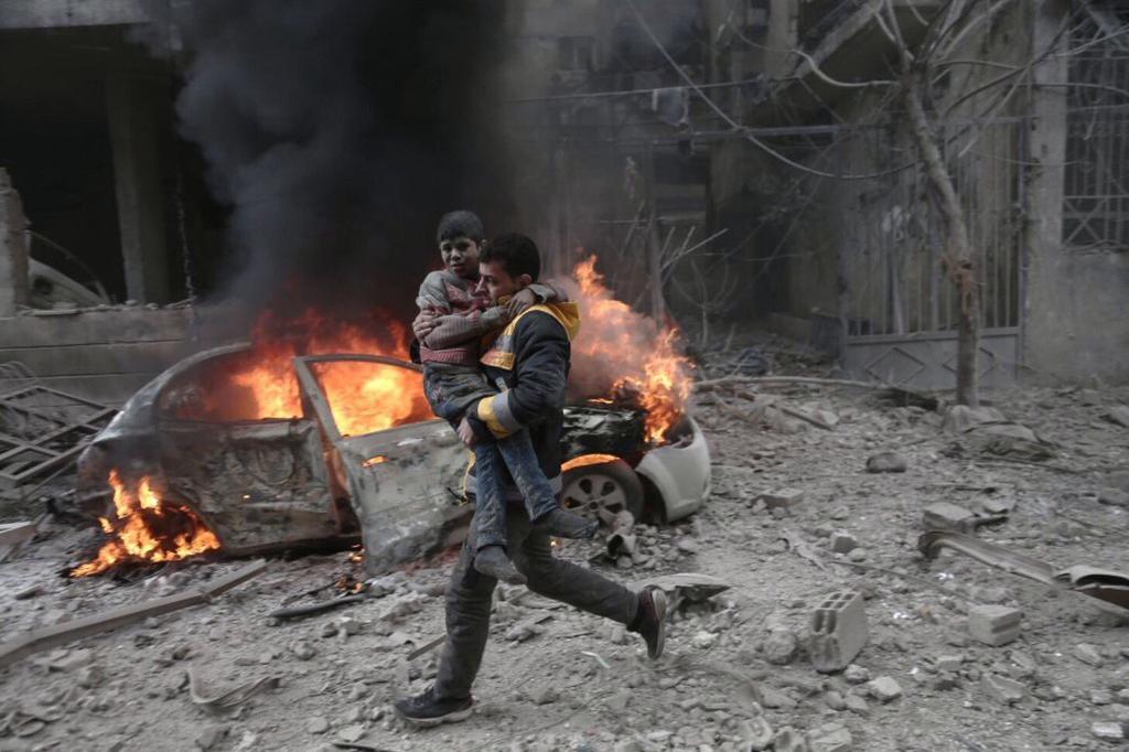
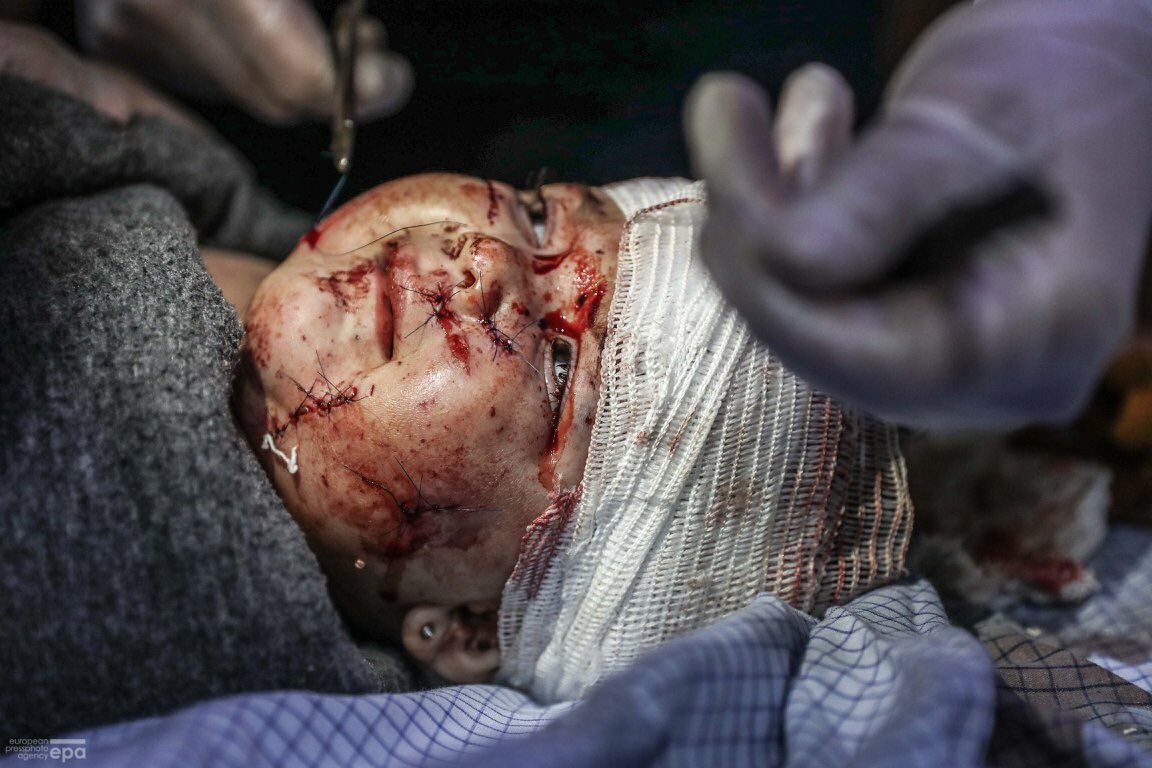
A Syria Civil Defence member carries a wounded child in the besieged town of Hamoria, Eastern Ghouta, in Damascus, Syria Photo @BassamKhabieh: image via Reuters Pictures @reuterspictures, 13 January 2018
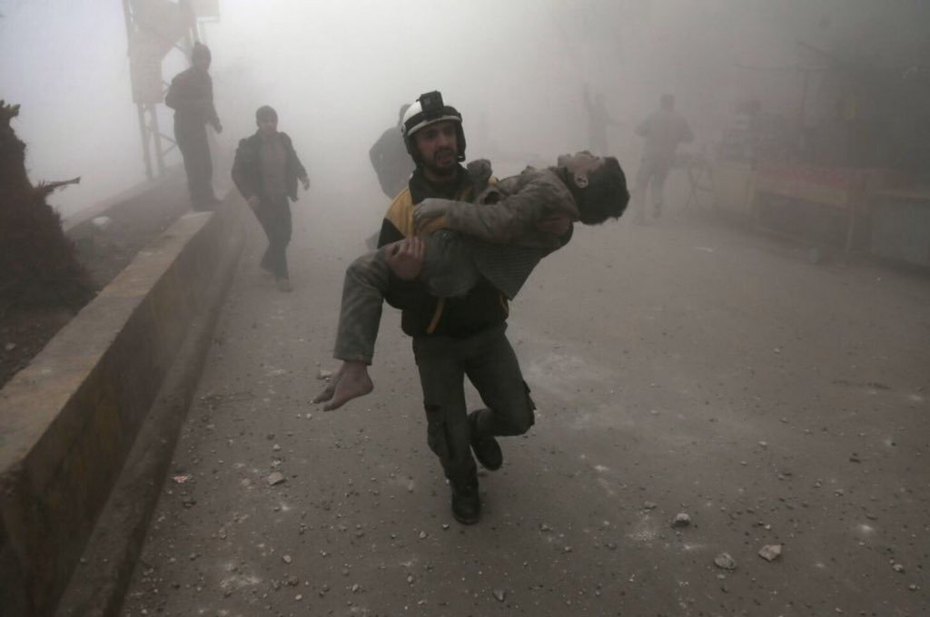
This is a part of the most powerful pictures in the world for last week, all of them taken following airstrikes by the Syrian government forces on the besieged Eastern Ghouta near the Syrian capital Damascus. PHOTO By: ABDULMONAM EASSA Via / #AFP: image via Abdulmonam Eassa @abdfree2, 12 January 2018
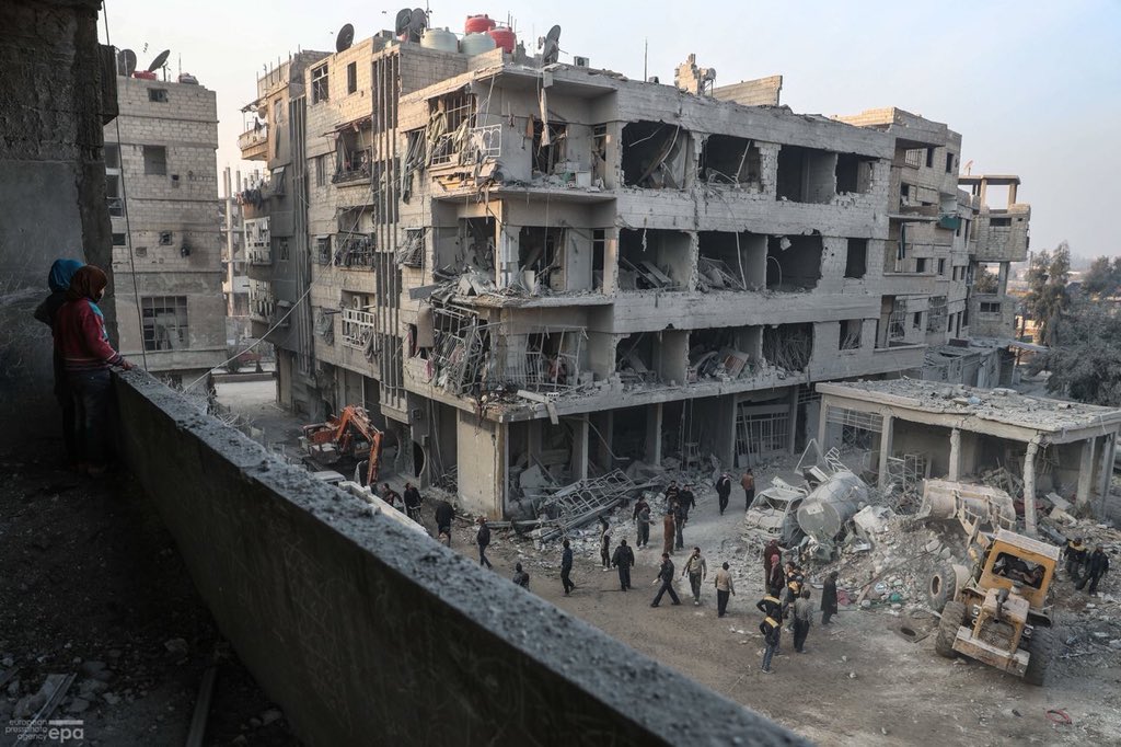
حمورية - الوقوف على الأطلال.. #Children look out from their destroyed home as #WhiteHelmets volunteers search for survivors after several air strikes destroyed civil buildings in #Hamoria city, al-Ghouta, #EasternGhouta #Damascus #WhiteHelmet @epaphotos @SyriaCivilDef: image via Mohammed Badra @badramamet, 10 January 2018
![]()
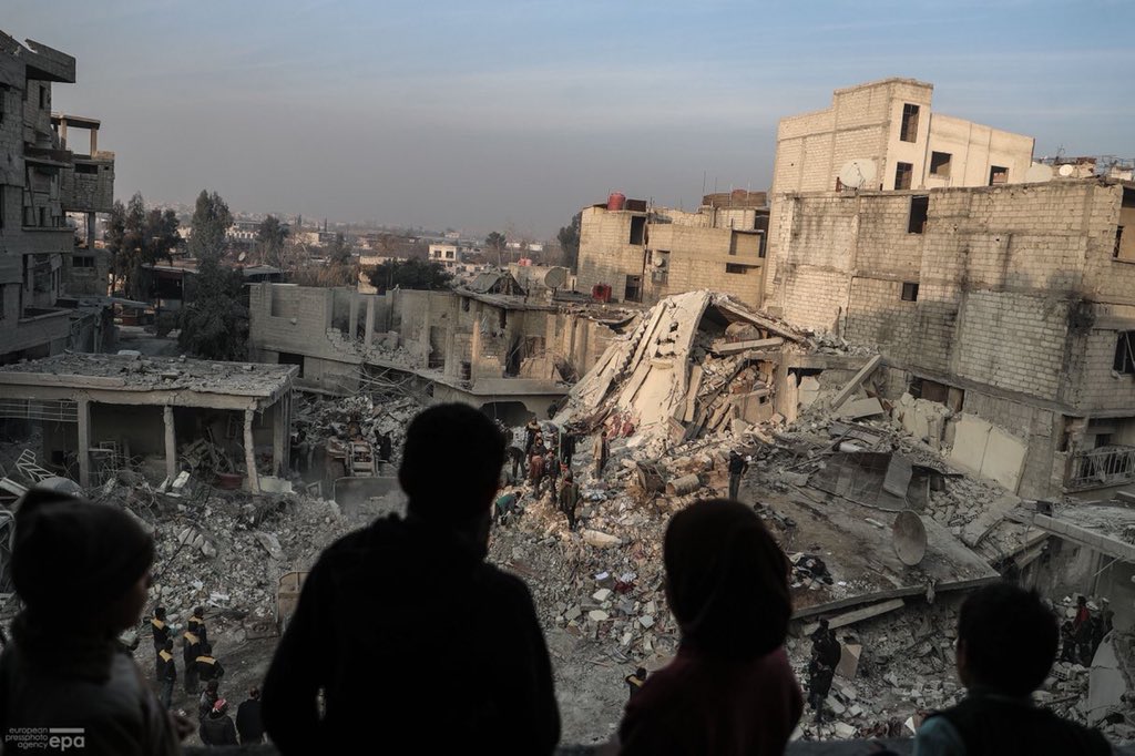
حمورية - الوقوف على الأطلال.. #Children look out from their destroyed home as #WhiteHelmets volunteers search for survivors after several air strikes destroyed civil buildings in #Hamoria city, al-Ghouta, #EasternGhouta #Damascus #WhiteHelmet @epaphotos @SyriaCivilDef: image via Mohammed Badra @badramamet, 10 January 2018
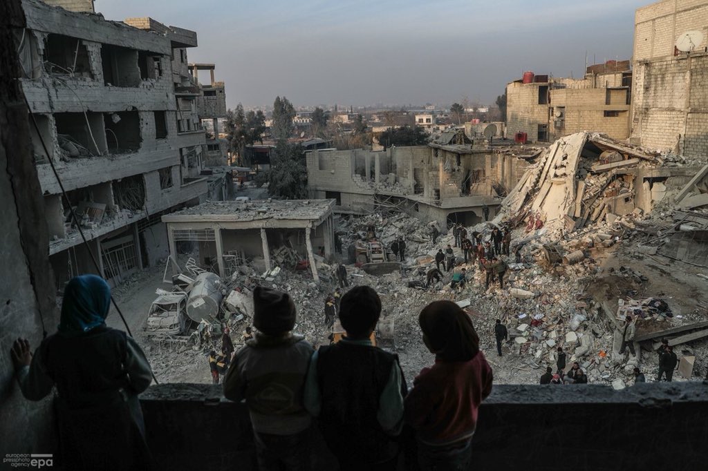
حمورية - الوقوف على الأطلال.. #Children look out from their destroyed home as #WhiteHelmets volunteers search for survivors after several air strikes destroyed civil buildings in #Hamoria city, al-Ghouta, #EasternGhouta #Damascus #WhiteHelmet @epaphotos @SyriaCivilDef: image via Mohammed Badra @badramamet, 10 January 2018
![]()
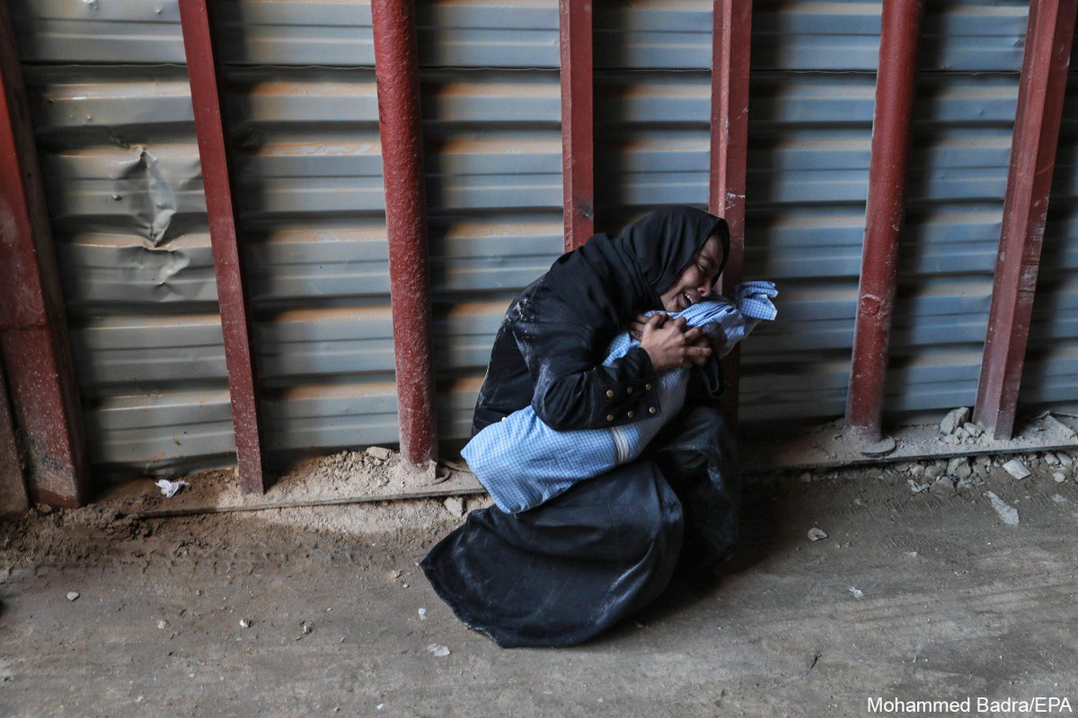
A mother weeps over her dead child Ameer who was wounded during airstrikes in Saqba and later died of his injuries #Douma #Ghouta #Syria #airstrikes Photo @badramamet: image via SundayTimesPictures @STPictures, 9 January 2018
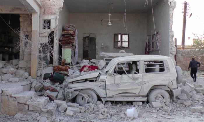
خلال الايام الماضية #Mesraba aftermath of air strikes #Damascus #EasternGhouta #Syria: image via Mohammed Badra @badramamet, 8 January 2018
خلال الايام الماضية #Mesraba aftermath of air strikes #Damascus #EasternGhouta #Syria: image via Mohammed Badra @badramamet, 8 January 2018
خلال الايام الماضية #Mesraba aftermath of air strikes #Damascus #EasternGhouta #Syria: image via Mohammed Badra @badramamet, 8 January 2018
خلال الايام الماضية #Mesraba aftermath of air strikes #Damascus #EasternGhouta #Syria: image via Mohammed Badra @badramamet, 8 January 2018
#Children of #Syria #EasternGhouta #childhood #injured @epaphotos: image via Mohammed Badra @badramamet, 5 January 2018
epa editor's choice 04 January 2018: #Mesraba #airstrikes #Syria #epaphotos Photo epa-efe / @badramamet : image via epaphotos @epaphotos, 4 January 2018
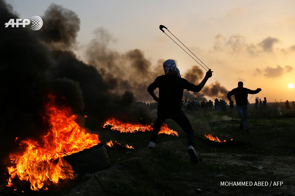
GAZA CITY - Palestinian protesters clash with Israeli security forces on the eastern outskirts of Gaza City, near the border with Israel. Photo @mohmdabed #AFP: image via Frédérique Geffard @fgeffardAFP, 12 January 2018
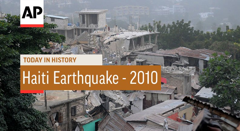
#OTD In 2010, Haiti was struck by a magnitude-7 earthquake: image via AP Archives @AP_Archive, 12 January 2018
![]()
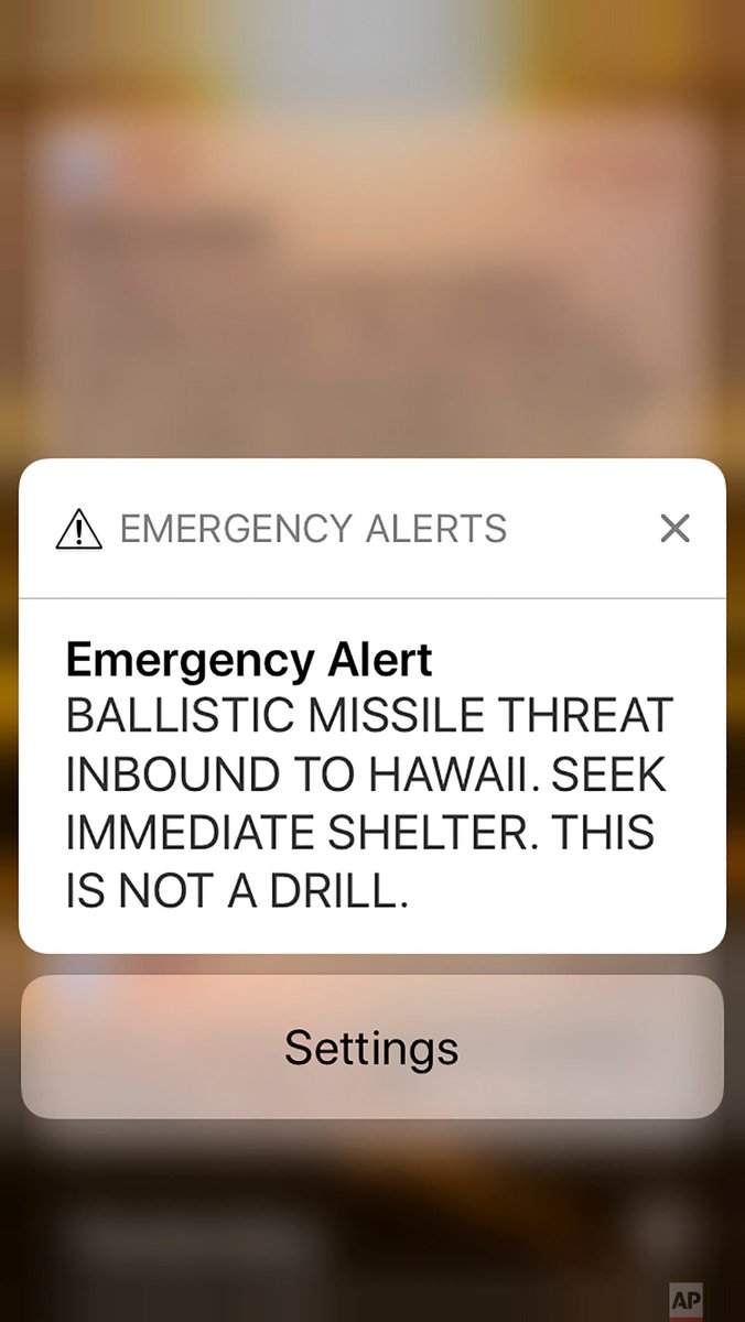
Hawaii officials mistakenly warn of inbound missile, sending residents into a full-blown panic Saturday: image via AP Images @AP_Images, 13 January 2018
![None]()
This smartphone screen capture shows a false incoming ballistic missile emergency alert sent from the Hawaii Emergency Management Agency system on Saturday, Jan. 13, 2018.: photo by Marco Garcia/AP, 13 January 2018
![]()
Cars on the freeway in Honolulu. Officials said the alert was caused by human error.: photo by Anthony Quintano/Honolulu Civil Beat, 13 January 2018
Hawaii officials mistakenly warn of inbound missile, sending residents into a full-blown panic Saturday: image via AP Images @AP_Images, 13 January 2018

This smartphone screen capture shows a false incoming ballistic missile emergency alert sent from the Hawaii Emergency Management Agency system on Saturday, Jan. 13, 2018.: photo by Marco Garcia/AP, 13 January 2018
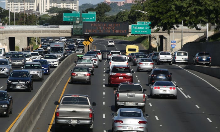
Cars on the freeway in Honolulu. Officials said the alert was caused by human error.: photo by Anthony Quintano/Honolulu Civil Beat, 13 January 2018
Hawaii ballistic missile false alarm prompts panic – and whisky drinking: Julia Carrie Wong in San Francisco and Liz Barney in Oahu for The Guardian, 13 January 2018
An alert about an incoming ballistic missile sent Hawaii into panic for about 30 minutes on Saturday, until emergency officials announced that the message had been sent in error.
The alert, which was sent to cellphones, said there was a threat “inbound to Hawaii” and said residents should seek shelter. “This is not a drill,” it added.
Tensions between the Trump administration and nuclear-armed North Korea have increased over fears the regime in Pyongyang may be able to reach US territory with a nuclear-armed missile.
Hawaiian authorities have been preparing and testing early warning systems, and residents have been urged to make emergency plans.
“Everyone’s got a plan,” said Ashly Trask, 39, who lives on the island of Kauai. “It’s very real.”
Trask’s home, like many on the islands, is constructed with single-ply walls and has no basement. When the alert came, Trask said, she piled her mother, 15-year-old son, two-year-old daughter and partner into the car, swung by her other son’s workplace to pick him up, and then sped to her office at the botanical gardens: a building with concrete walls that is used as a hurricane shelter.
“It was definitely kind of a panic zone,” she said. “Everyone knows you have about 15 minutes until detonation, and no one knows where it will land.”
Family members on the other side of the island were too far away to get to the gardens within that short timespan.
“They called us and they were crying because they realized they wouldn’t have made it to us,” Trask said.
In western Oahu, people ran out of buildings into the streets. According to a witness, some took shelter in the basement of a parking structure, where people cried and children huddled on rolls of fabric.
Approximately 30 minutes later, authorities said the alert was a mistake.
Many in the parking shelter hugged, cried, shook and prepared to head back outside.
Others said they would remain undercover until they received confirmation from the coast guard that all was safe.
Hawaii governor David Ige told CNN the false alarm was caused by human error. “It was a mistake made during a standard procedure at the change over of a shift, and an employee pushed the wrong button,” he said.
![]()
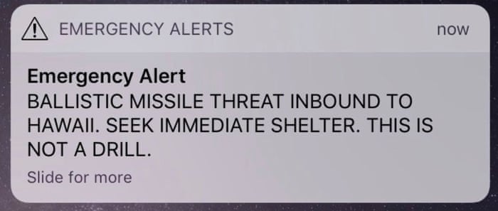
The alert text: photo by Hawaii Emergency Management Agency, 13 January 2018
The alert came as Oahu staged a 100-mile endurance run, the HURT100. Some runners sheltered under a bridge before resuming racing.
Beth Ann Brooks of Haleiwa told the Guardian she was at the beach when she received the alert and raced home. She and her husband sheltered in their bathroom, she said.
“We grabbed couch cushions and our hurricane kit and water and sat there talking to the kids and trying to calm them down,” Brooks said. “They didn’t say much. It was horrible. The fear I felt was unlike anything I’ve ever experienced.”
The US congresswoman Tulsi Gabbard tweeted that the alert was an error, writing: “HAWAII – THIS IS A FALSE ALARM. THERE IS NO INCOMING MISSILE TO HAWAII. I HAVE CONFIRMED WITH OFFICIALS THERE IS NO INCOMING MISSILE.”
A White House statement said Donald Trump had been “briefed on the state of Hawaii’s emergency management exercise”.
For some, the prospect of the end of the world was an opportunity to indulge. Joshua Keoki Versola was home alone in Mililani when he received the alert. As he waited for his fiancee to drive home from her place of work, the 35-year-old network engineer opened a bottle of Hibiki 21, an award-winning and expensive Japanese whisky.
“I was about to start pouring drinks and go out in style,” Versola said “What are we going to do in this situation? We really can’t do anything but just try and make the best of it.”
![]()

US - A Donald Trump impersonator with a bikini clad model stops at a hot dog vendor near Trump Tower in New York. By @timothyaclary #AFP: image via Frédérique Geffard @fgeffardAFP, 25 October 2016
![]()
Visibility just outside Delhi - smog back to ‘Hazardous’ levels: image via michael safi @safimichael, 20 December 2017
![]()
a most cursed image: image via Anna Livsey @annalivsey, 20 December 2017
![]()
it has come to my attention that reindeer have incredibly soft looking schnozzes. this is important.: image via Anna Livsey @annalivsey, 20 December 2017
![the one and only documented image of the landing zone of extraterrestrial flying objects in Belgium | by glasseyes view]()
![the one and only documented image of the landing zone of extraterrestrial flying objects in Belgium | by glasseyes view]()
![the one and only documented image of the landing zone of extraterrestrial flying objects in Belgium | by glasseyes view]()
the one and only documented image of the landing zone of extraterrestrial flying objects in Belgium. Believe it or leave it.: photo by glasseyes view, 12 January 2018
![People in glass houses throwing shithole comments around... | by rickele]()
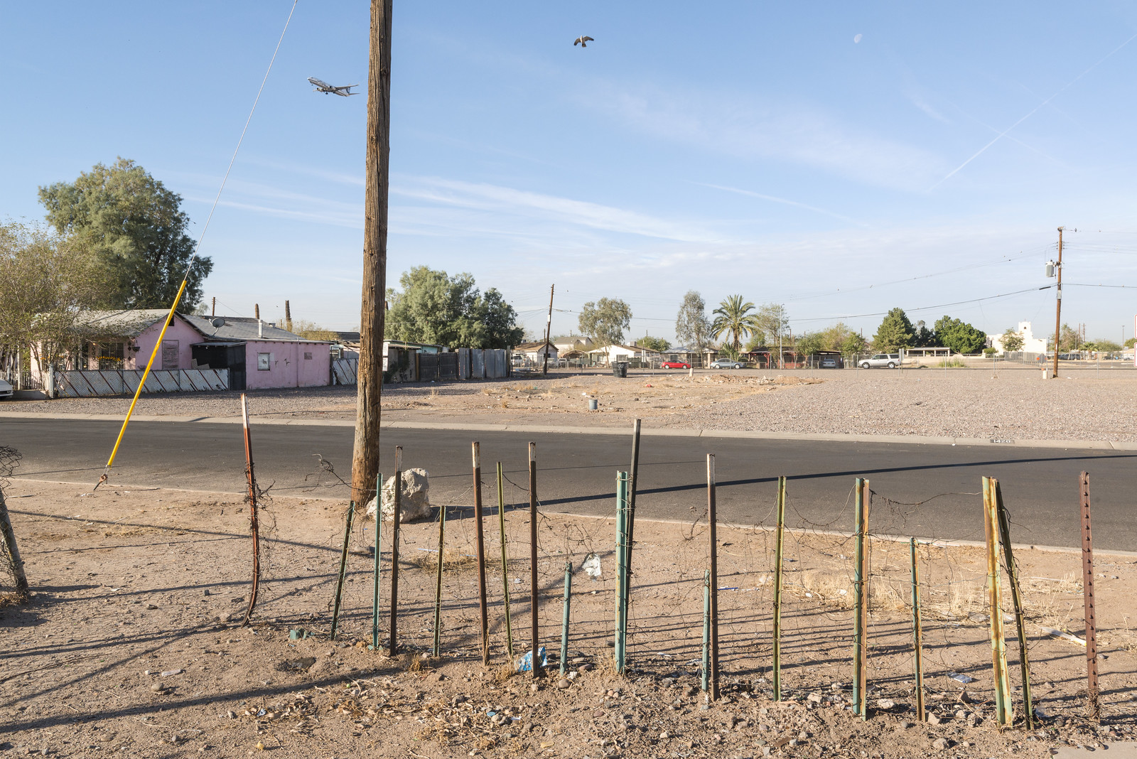
![Central City South | by GC_Dean]()
![Central City South | by GC_Dean]()
![Central City South | by GC_Dean]()
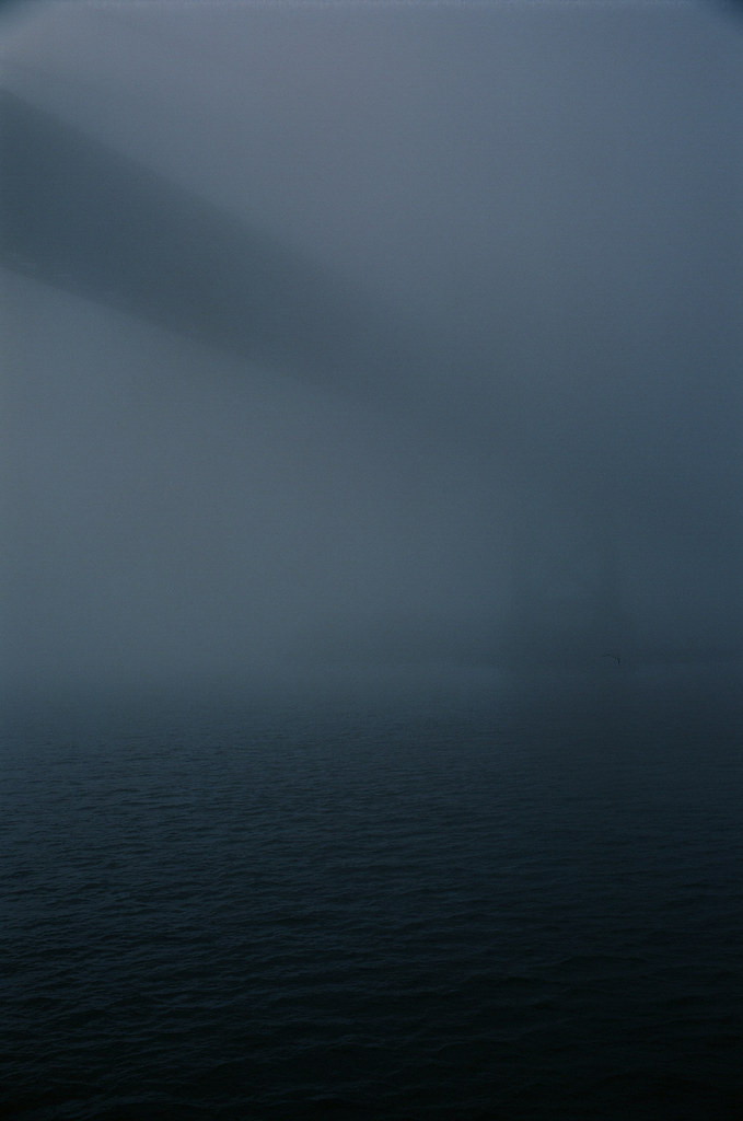
![Bay Bridge in the Fog | by Robert Ogilvie]()
![Compton, CA | by Mike Murphy -]()
![Compton, CA | by Mike Murphy -]()
![Compton, CA | by Mike Murphy -]()
Car Art: photo by Patricia Jeremiah, 13 January 2018
Visibility just outside Delhi - smog back to ‘Hazardous’ levels: image via michael safi @safimichael, 20 December 2017

a most cursed image: image via Anna Livsey @annalivsey, 20 December 2017

it has come to my attention that reindeer have incredibly soft looking schnozzes. this is important.: image via Anna Livsey @annalivsey, 20 December 2017
anywhere out of this world
the one and only documented image of the landing zone of extraterrestrial flying objects in Belgium. Believe it or leave it.: photo by glasseyes view, 12 January 2018
the one and only documented image of the landing zone of extraterrestrial flying objects in Belgium. Believe it or leave it.: photo by glasseyes view, 12 January 2018
the one and only documented image of the landing zone of extraterrestrial flying objects in Belgium. Believe it or leave it.: photo by glasseyes view, 12 January 2018
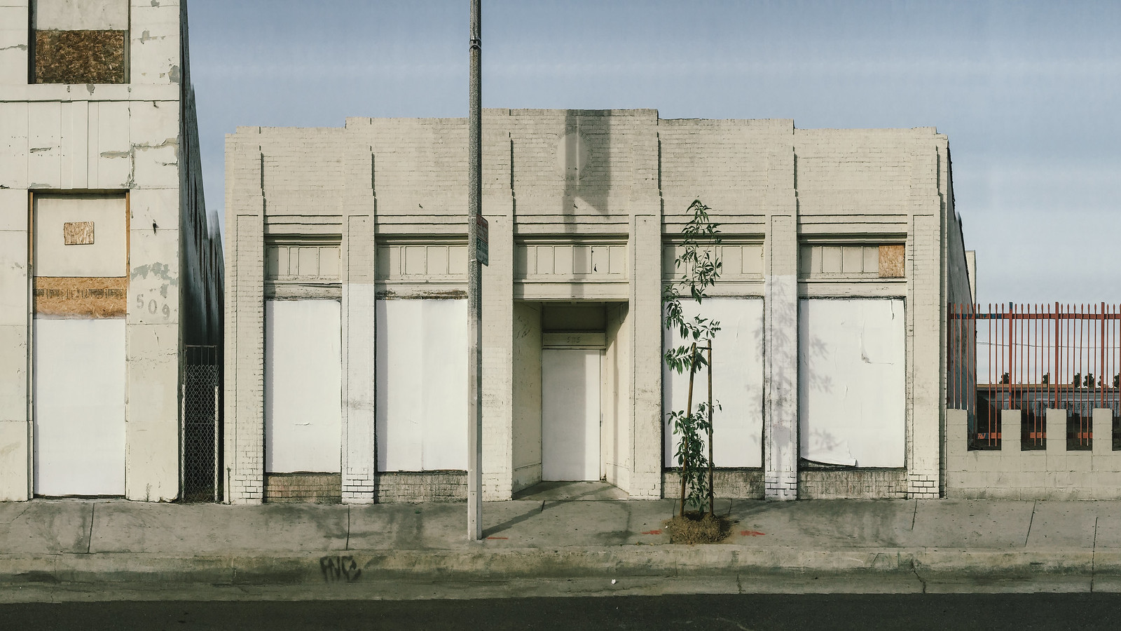
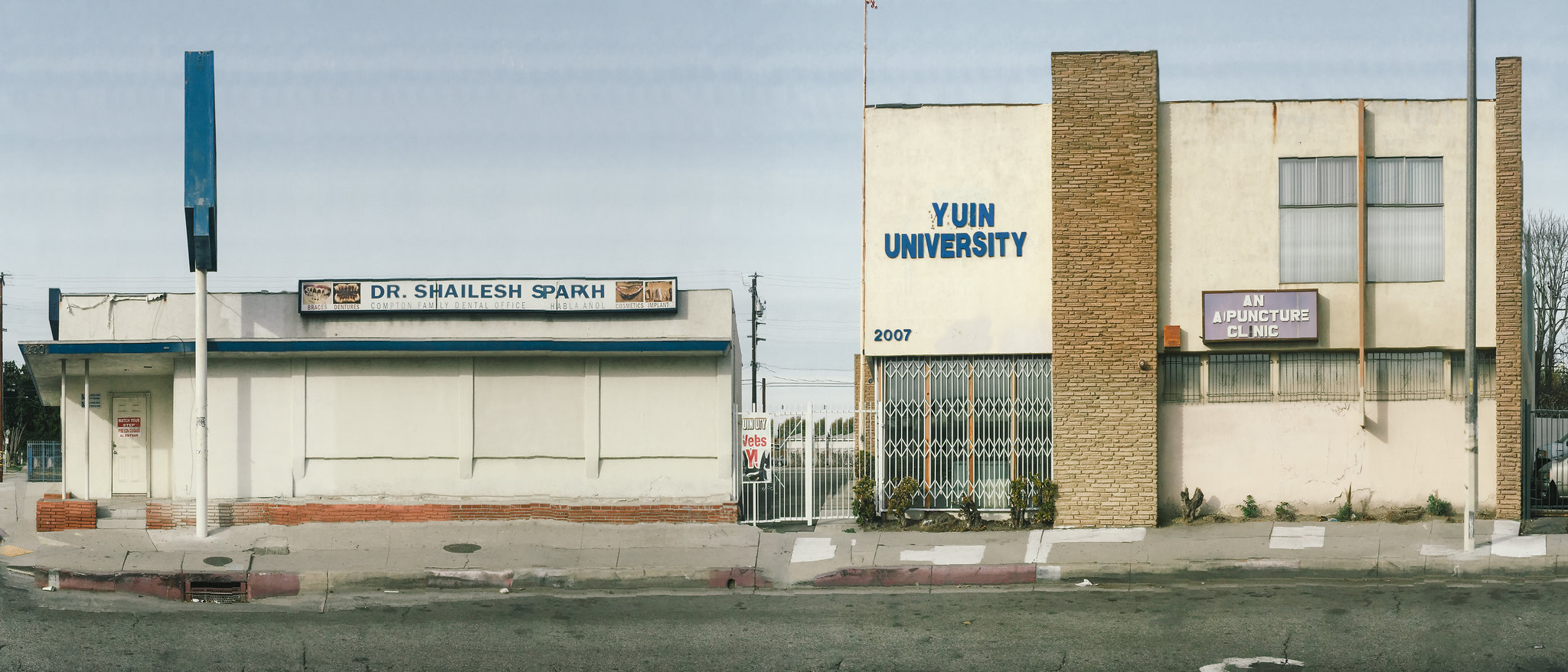
Compton, CA: photo by Mike Murphy, 10 December 2017
![Bay Bridge in the Fog 2 | by Robert Ogilvie]()
![Compton, CA | by Mike Murphy -]()
Compton, CA: photo by Mike Murphy, 10 December 2017
![Compton, CA | by Mike Murphy -]()
Compton, CA: photo by Mike Murphy, 10 December 2017
![Compton, CA | by Mike Murphy -]()
Compton, CA: photo by Mike Murphy, 10 December 2017
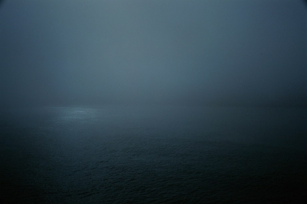
![Sunlight on San Francisco Bay | by Robert Ogilvie]()
Sunlight on San Francisco Bay | San Francisco, CA: photo by Robert Ogilvie, 13 January 2018
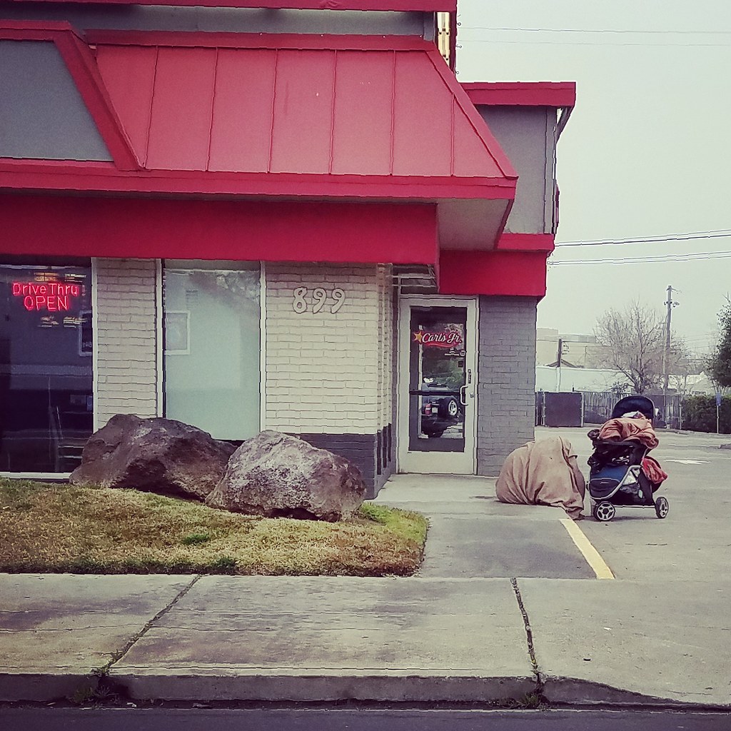
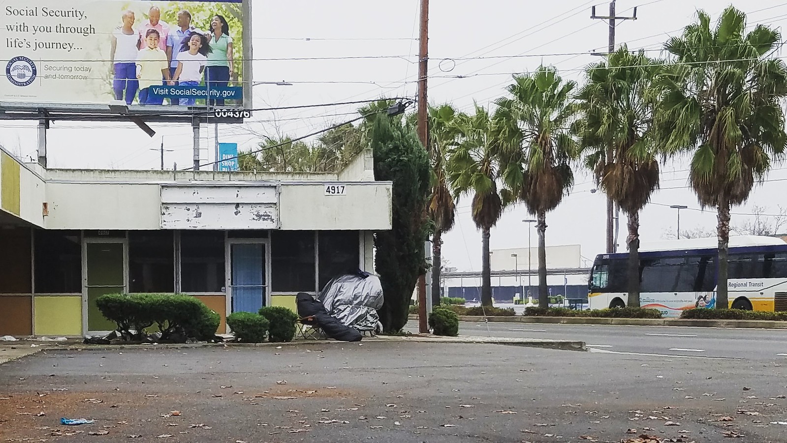
![But what if your journey detours to here? | by rickele]()
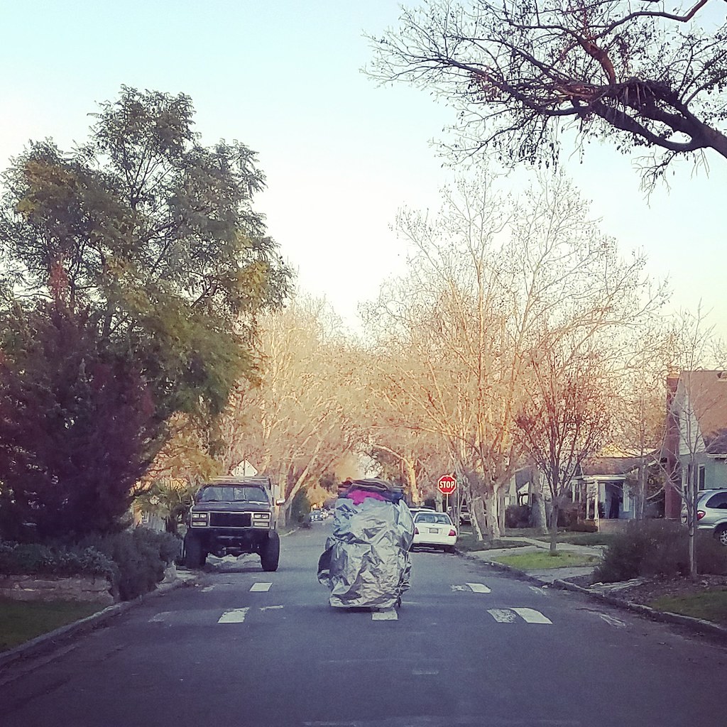
But what if your journey detours to here? | He slept through night and drizzly early AM hours just like that, stiff as a board in that cocoon-like garb. A Sacramento police officer moved him along without incident by 9:30. [Stockton Boulevard, Old US Route 99, Sacramento]: photo by Rick Ele, 12 January 2018
![But what if your journey detours to here? | by rickele]()
But what if your journey detours to here? | He slept through night and drizzly early AM hours just like that, stiff as a board in that cocoon-like garb. A Sacramento police officer moved him along without incident by 9:30. [Stockton Boulevard, Old US Route 99, Sacramento]: photo by Rick Ele, 12 January 2018
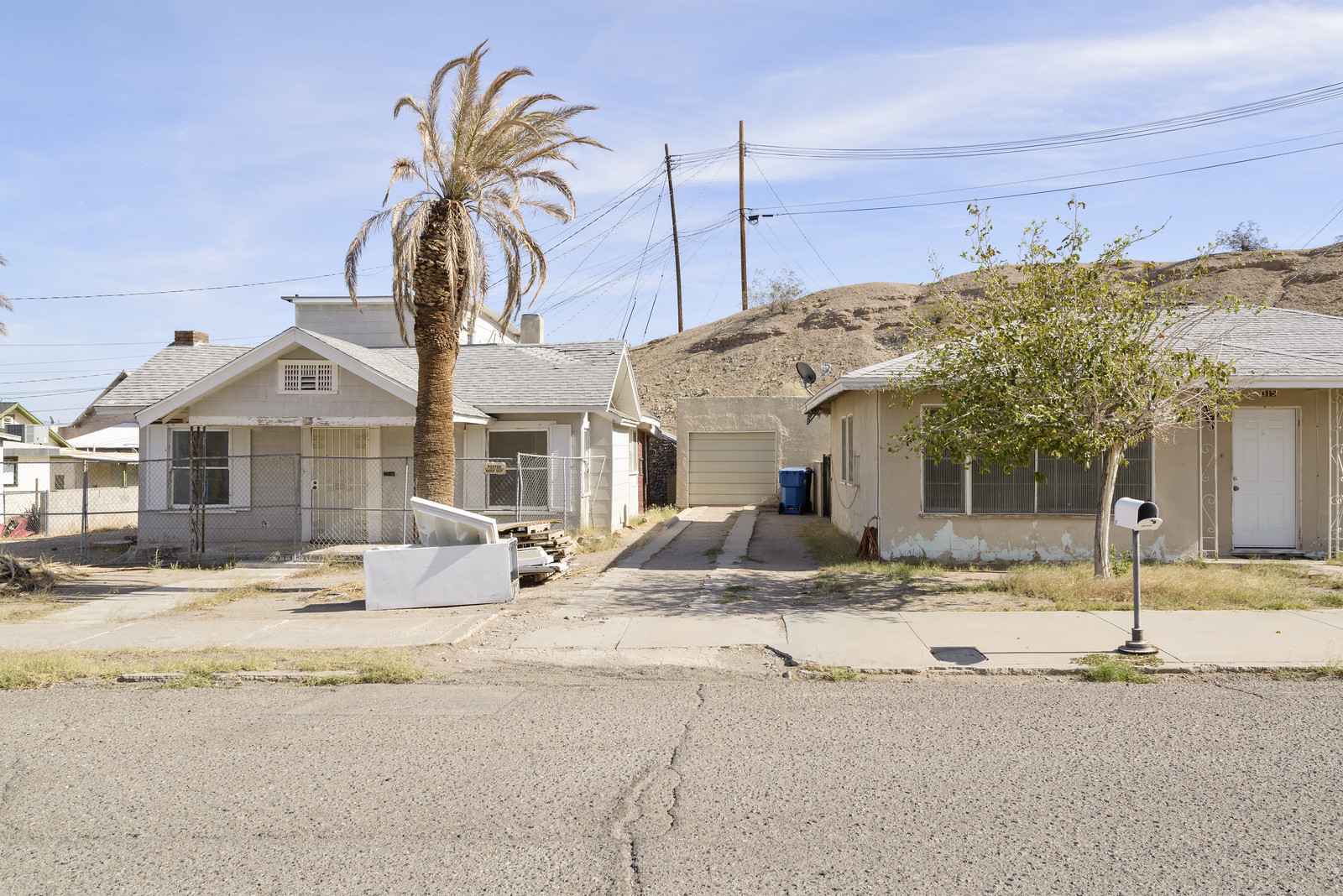
![Needles, California | by GC_Dean]()
![Needles, California | by GC_Dean]()
![Needles, California | by GC_Dean]()
Needles, California: photo by Dean Terasaki, 17 October 2017
![Car Art | by patrog5]()
![Car Art | by patrog5]()
![Car Art | by patrog5]()
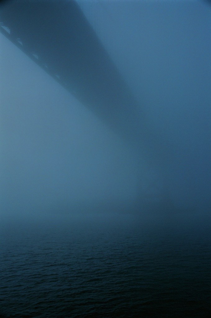
Bay Bridge in the Fog 2 | San Francisco, CA: photo by Robert Ogilvie, 13January 2018
![Daily Migration for Anywhere Else to Rest | by rickele]()
Compton, CA: photo by Mike Murphy, 10 December 2017
Compton, CA: photo by Mike Murphy, 10 December 2017
Compton, CA: photo by Mike Murphy, 10 December 2017
Sunlight on San Francisco Bay | San Francisco, CA: photo by Robert Ogilvie, 13 January 2018
But what if your journey detours to here? | He slept through night and drizzly early AM hours just like that, stiff as a board in that cocoon-like garb. A Sacramento police officer moved him along without incident by 9:30. [Stockton Boulevard, Old US Route 99, Sacramento]: photo by Rick Ele, 12 January 2018
But what if your journey detours to here? | He slept through night and drizzly early AM hours just like that, stiff as a board in that cocoon-like garb. A Sacramento police officer moved him along without incident by 9:30. [Stockton Boulevard, Old US Route 99, Sacramento]: photo by Rick Ele, 12 January 2018
But what if your journey detours to here? | He slept through night and drizzly early AM hours just like that, stiff as a board in that cocoon-like garb. A Sacramento police officer moved him along without incident by 9:30. [Stockton Boulevard, Old US Route 99, Sacramento]: photo by Rick Ele, 12 January 2018
Needles, California: photo by Dean Terasaki, 17 October 2017

Car Art: photo by Patricia Jeremiah, 13 January 2018
Wislawa Szymborska:Map (where the shitholes are)
This is the map of the #shithole countries: image via Bali_Pikin_njenka @lensnouvel, 13 January 2018 from Centre, Cameroon
Wislawa Szymborska:Map
Flat as the tableit’s placed on.
Nothing moves beneath it
and it seeks no outlet.
Above -- my human breath
creates no stirring air
and leaves its total surface
undisturbed.
Its plains, valleys are always green,
uplands, mountains are yellow and brown,
while seas, oceans remain a kindly blue
beside the tattered shores.
Everything here is small, near, accessible.
I can press volcanoes with my fingertip,
stroke the poles without thick mittens,
I can with a single glance
encompass every desert
with the river lying just beside it.
A few trees stand for ancient forests,
you couldn’t lose your way among them.
In the east and west,
above and below the equator --
quiet like pins dropping,
and in every black pinprick
people keep on living.
Mass graves and sudden ruins
are out of the picture.
Nations’ borders are barely visible
as if they wavered -- to be or not.
I like maps, because they lie.
Because they give no access to the vicious truth.
Because great-heartedly, good-naturedly
they spread before me a world
not of this world.
Wislawa Szymborska (1923-2012): Map, 2012, translated by Clare Cavanagh in Map: Collected and Last Poems, 2015


Novissima et Accuratissima Totius Americae Descriptio: Johannnes de Ram, c. 1685, engraving
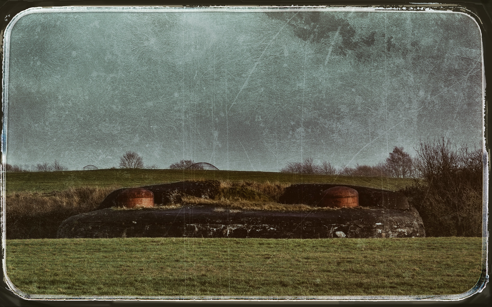
![Geology (near Lovell WY) | by The Amazing Mr. Ripley]()
![Geology (near Lovell WY) | by The Amazing Mr. Ripley]()
![Geology (near Lovell WY) | by The Amazing Mr. Ripley]()

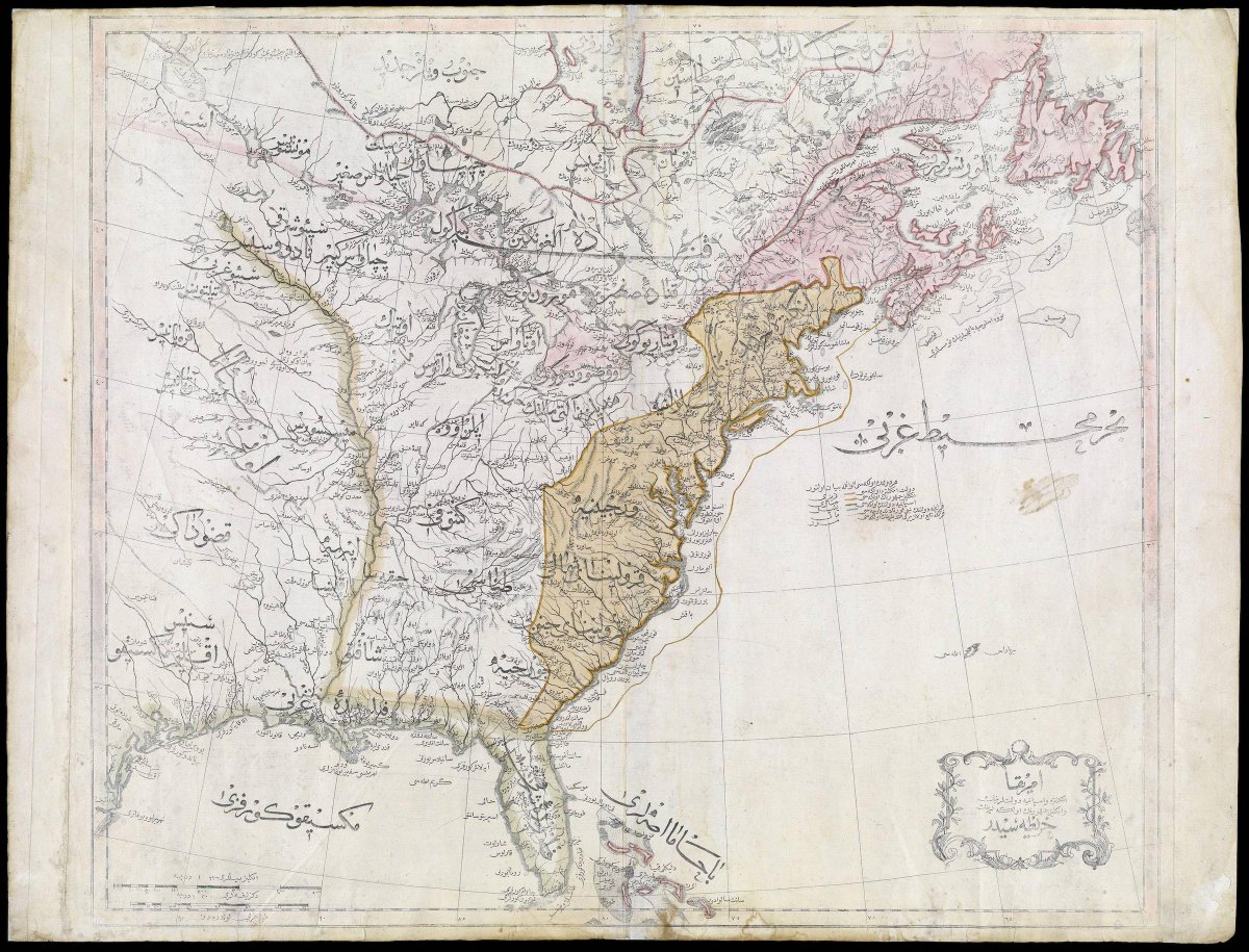
First Ottoman map of the United States): image via Amazing Maps @Amazing_Maps, 22 July 2015

World Map: Benedetto Bordone, 1528, woodcut, 325 x 165 mm (British Library, London)

Lion Map (Leo Belgicus): Claes Jansz Visscher the Younger, 1609, coloured etching and engraving, 470 x 572 mm (Stichting Atlas van Stolk, Rotterdam)

![[synthetica.jpg]](http://3.bp.blogspot.com/_fdAsVFXbwvk/Su8JheOMZ-I/AAAAAAAAAyA/PHdXHvviJnU/s1600/synthetica.jpg)
New York: map of Flickr and Twitter locations. Red dots are locations of Flickr pictures. Blue dots are locations of Twitter tweets. White dots are locations that have been posted to both: image by Eric Fischer (See something or say something), 7 July 2011
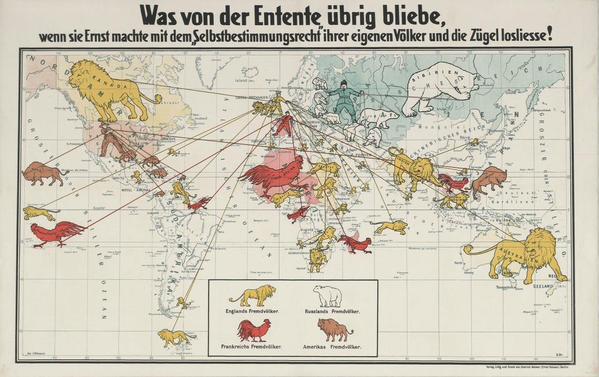
German propaganda map showing the Allies' colonial empires (c1916): image via Amazing Maps @Amazing_Maps, 24 July 2015
![]()
Leo Belgicus: Hendrik Floris van Langren, before 1609, hand coloured engraving and etching, 368 x 450 mm (National Széchényi Library, Budapest) ![File:Accurata Utopiae Tabula.jpg]()
Accurata Utopia Tabula (Karte des Schlaraffenlandes): Matthäus Seutter (1678-1757), via Barry Lawrence Ruderman Antique Maps; image by Goustien, 19 February 2009
![]()
The Island of Utopia: Ambrosius Holbein, 1518, woodcut, 17.8 x 11.8 cm (Öffentliche Kunstsammlung, Basel)
![INDUSTRIAL CHEMICALS TIME 10/04/1963 p. 9]()
Celanese Plastics advertisement: Time, 4 October 1963 (Gallery of Graphic Design)
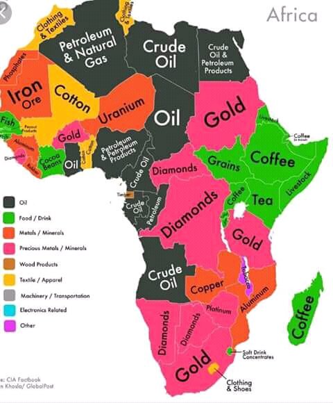
”RT @Mr_Bata: The South African map of Africa. @zapiro at his best! #Xenophobia: image via Rachael Akidi @rakidi, 20 April 2015
![]()
Some military instructions in Hebrew and a map of a school are seen on a blackboard after Israeli soldiers withdrew from the Beit Hanun High school for girls which was reportedly used as an advance base during Israel's military offensive against the Gaza Strip: photo by Marco Longari/AFP, 5 August 2014
![Embedded image permalink]()

From October 1999 through March 2012, 2,269 deaths were recorded at the Arizona-Mexico border. Water stations, placed by the nonprofit Humane Borders, are intended to mitigate the deaths. Source: Migrant death map provided courtesy of Humane Borders, Inc. Data development by John F. Chamblee, Michael Malone, and Mathew Reynolds: image via Newsweek, 10 July 2013
![]()
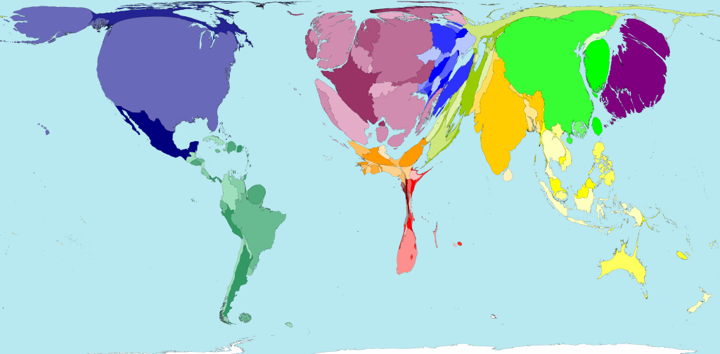
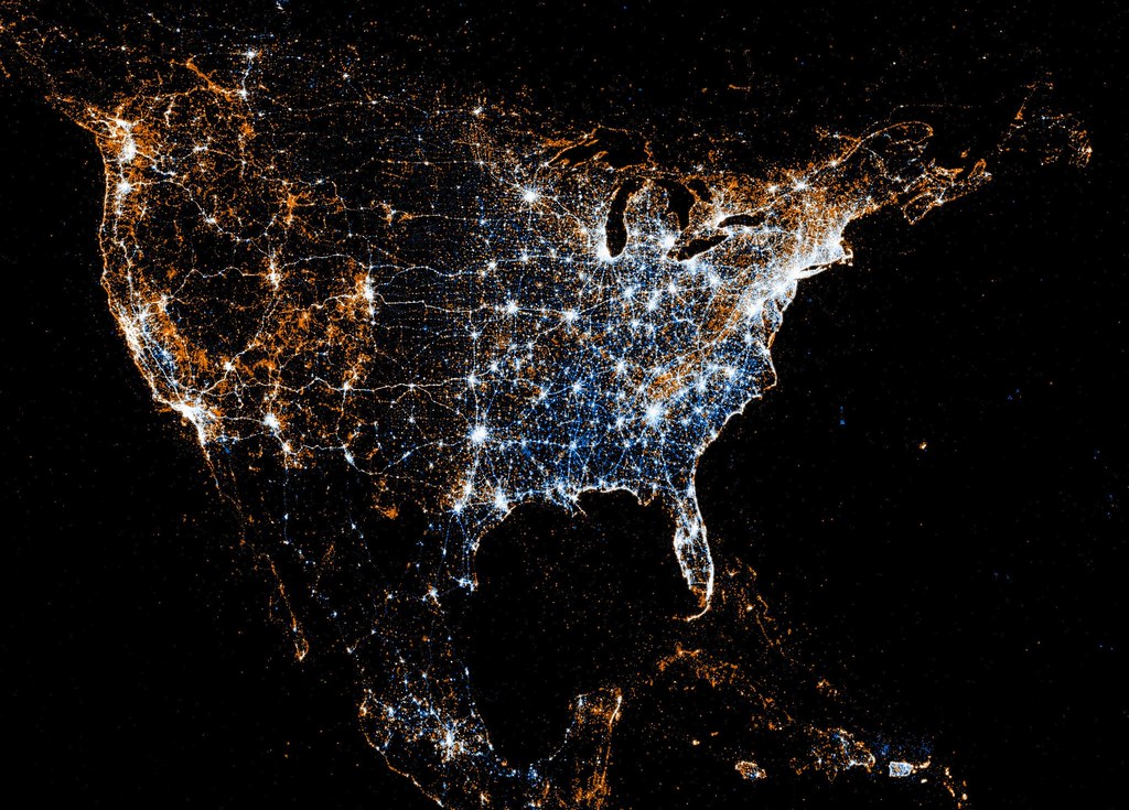
World map of Flickr and Twitter locations. Red dots are locations of Flickr pictures. Blue dots are locations of Twitter tweets. White dots are locations that have been posted to both: image by Eric Fischer (See something or say something), 7 July 2011
Average monthly disposable salary in USD: image via Amazing Maps @Amazing_Maps, 17 July 2015
![]()
European detail map of Flickr and Twitter locations. Red dots are locations of Flickr pictures. Blue dots are locations of Twitter tweets. White dots are locations that have been posted to both: image by Eric Fischer (See something or say something), 7 July 2011
London: map of Flickr and Twitter locations. Red dots are locations of Flickr pictures. Blue dots are locations of Twitter tweets. White dots are locations that have been posted to both: image by Eric Fischer (See something or say something), 7 July 2011
![]()
San Francisco: map of Flickr and Twitter locations. Red dots are locations of Flickr pictures. Blue dots are locations of Twitter tweets. White dots are locations that have been posted to both: image by Eric Fischer (See something or say something), 7 July 2011
Heavy metal bands per 100,000 people: image via Amazing Maps @Amazing_Maps, 8 October 2013
![]()
Moscow: map of Flickr and Twitter locations. Red dots are locations of Flickr pictures. Blue dots are locations of Twitter tweets. White dots are locations that have been posted to both: image by Eric Fischer (See something or say something), 7 July 2011
Cigarette consumption by country: image via Amazing Maps @Amazing_Maps, 30 July 2015
![]()
Paris: map of Flickr and Twitter locations. Red dots are locations of Flickr pictures. Blue dots are locations of Twitter tweets. White dots are locations that have been posted to both: image by Eric Fischer (See something or say something), 7 July 2011


Accurata Utopia Tabula (Karte des Schlaraffenlandes): Matthäus Seutter (1678-1757), via Barry Lawrence Ruderman Antique Maps; image by Goustien, 19 February 2009

The Island of Utopia: Ambrosius Holbein, 1518, woodcut, 17.8 x 11.8 cm (Öffentliche Kunstsammlung, Basel)

Celanese Plastics advertisement: Time, 4 October 1963 (Gallery of Graphic Design)

”RT @Mr_Bata: The South African map of Africa. @zapiro at his best! #Xenophobia: image via Rachael Akidi @rakidi, 20 April 2015

Some military instructions in Hebrew and a map of a school are seen on a blackboard after Israeli soldiers withdrew from the Beit Hanun High school for girls which was reportedly used as an advance base during Israel's military offensive against the Gaza Strip: photo by Marco Longari/AFP, 5 August 2014
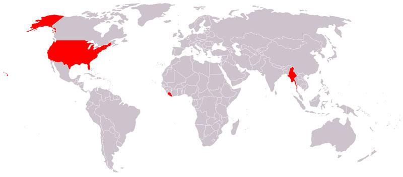
The only countries that don't use the metric system are Liberia, Myanmar, and the United States: image via Belal Dabour - Gaza @Belalmd12, 29 September 2014

From October 1999 through March 2012, 2,269 deaths were recorded at the Arizona-Mexico border. Water stations, placed by the nonprofit Humane Borders, are intended to mitigate the deaths. Source: Migrant death map provided courtesy of Humane Borders, Inc. Data development by John F. Chamblee, Michael Malone, and Mathew Reynolds: image via Newsweek, 10 July 2013

Colours of passports around the world: image via Amazing Maps @Amazing_Maps, 4 August 2015
World map of Flickr and Twitter locations. Red dots are locations of Flickr pictures. Blue dots are locations of Twitter tweets. White dots are locations that have been posted to both: image by Eric Fischer (See something or say something), 7 July 2011

Average monthly disposable salary in USD: image via Amazing Maps @Amazing_Maps, 17 July 2015

European detail map of Flickr and Twitter locations. Red dots are locations of Flickr pictures. Blue dots are locations of Twitter tweets. White dots are locations that have been posted to both: image by Eric Fischer (See something or say something), 7 July 2011
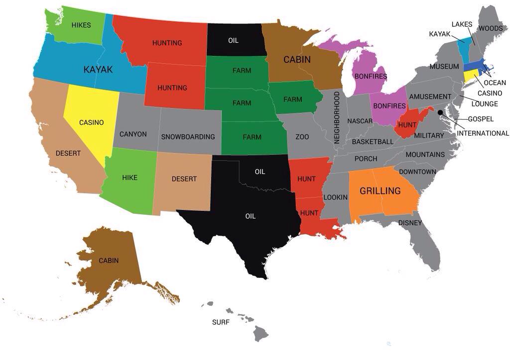
Most popular word used in online dating profiles by state: image via Amazing Maps @Amazing_Maps, 9 August 2015
![]()
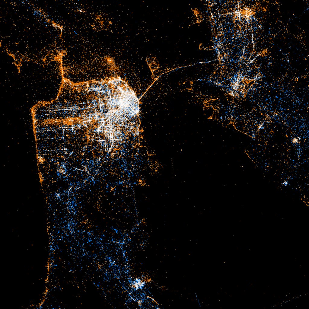
North American detail map of Flickr and Twitter locations. Red dots are locations of Flickr pictures. Blue dots are locations of Twitter tweets. White dots are locations that have been posted to both: image by Eric Fischer (See something or say something), 7 July 2011
North American detail map of Flickr and Twitter locations. Red dots are locations of Flickr pictures. Blue dots are locations of Twitter tweets. White dots are locations that have been posted to both: image by Eric Fischer (See something or say something), 7 July 2011
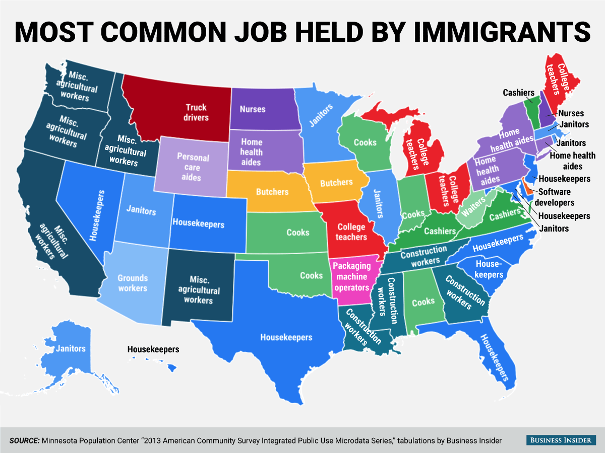
Most common job held by immigrants in the USA: image via Amazing Maps @Amazing_Maps, 18 August 2015
![]()

London: map of Flickr and Twitter locations. Red dots are locations of Flickr pictures. Blue dots are locations of Twitter tweets. White dots are locations that have been posted to both: image by Eric Fischer (See something or say something), 7 July 2011

Greater Tokyo area superimposed over Great Britain: image via Amazing Maps @Amazing_Maps, 14 August 2015
San Francisco: map of Flickr and Twitter locations. Red dots are locations of Flickr pictures. Blue dots are locations of Twitter tweets. White dots are locations that have been posted to both: image by Eric Fischer (See something or say something), 7 July 2011

Heavy metal bands per 100,000 people: image via Amazing Maps @Amazing_Maps, 8 October 2013
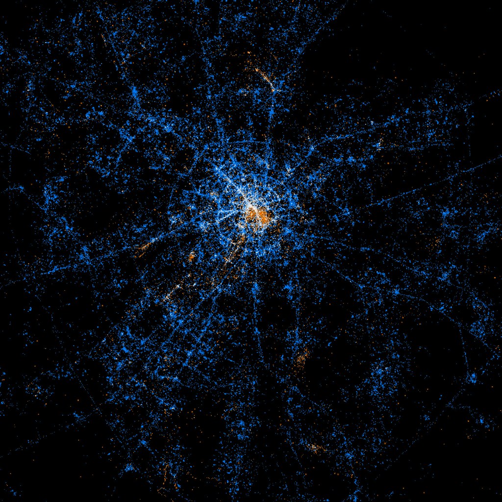
Moscow: map of Flickr and Twitter locations. Red dots are locations of Flickr pictures. Blue dots are locations of Twitter tweets. White dots are locations that have been posted to both: image by Eric Fischer (See something or say something), 7 July 2011
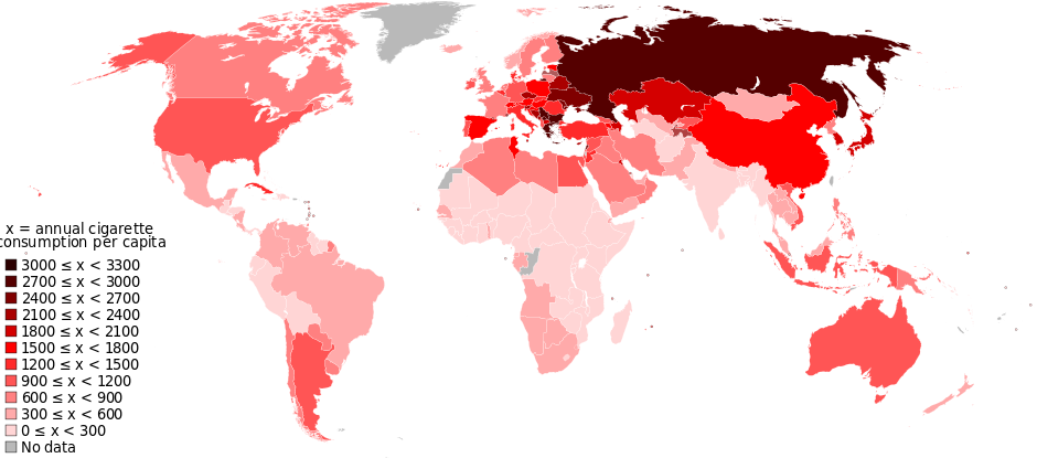
Cigarette consumption by country: image via Amazing Maps @Amazing_Maps, 30 July 2015
Paris: map of Flickr and Twitter locations. Red dots are locations of Flickr pictures. Blue dots are locations of Twitter tweets. White dots are locations that have been posted to both: image by Eric Fischer (See something or say something), 7 July 2011